IMAGES TAKEN NEAR TO
Browning Way, WINSFORD, CW7 2JN
Introduction
This page details the photographs taken nearby to Browning Way, CW7 2JN by members of the Geograph project.
The Geograph project started in 2005 with the aim of publishing, organising and preserving representative images for every square kilometre of Great Britain, Ireland and the Isle of Man.

There are currently over 7.5m images from over14,400 individuals and you can help contribute to the project by visiting https://www.geograph.org.uk
Image Map
Images are licensed for reuse under creativecommons.org/licenses/by-sa/2.0
Notes
- Clicking on the map will re-center to the selected point.
- The higher the marker number, the further away the image location is from the centre of the postcode.
Image Listing (6 Images Found)
Images are licensed for reuse under creativecommons.org/licenses/by-sa/2.0
Image
Details
Distance
1
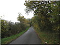
Looking North on Blakeden Lane Hebden Green
Image: © Dr Duncan Pepper
Taken: 13 Nov 2011
0.13 miles
2
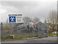
MOT Centre
This Royal Navy Sea Harrier ZE691 is at the entrance to this MOT Centre, also located next to the Winsford recycling centre, on an industrial estate, close to the Cheshire Police headquarters.
Image: © Andrew Fielding
Taken: 8 Nov 2010
0.15 miles
4
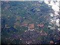
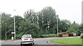
Hebden Green, Winsford
An aerial view from over the M6 between Knutsford and Sandbach
Image: © M J Richardson
Taken: 26 Sep 2015
0.20 miles
5
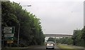
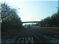
Footbridge just east of roundabout on A54
Image: © John Firth
Taken: 20 May 2014
0.23 miles