IMAGES TAKEN NEAR TO
Grange Court, WINSFORD, CW7 2HH
Introduction
This page details the photographs taken nearby to Grange Court, CW7 2HH by members of the Geograph project.
The Geograph project started in 2005 with the aim of publishing, organising and preserving representative images for every square kilometre of Great Britain, Ireland and the Isle of Man.

There are currently over 7.5m images from over14,400 individuals and you can help contribute to the project by visiting https://www.geograph.org.uk
Image Map
Images are licensed for reuse under creativecommons.org/licenses/by-sa/2.0
Notes
- Clicking on the map will re-center to the selected point.
- The higher the marker number, the further away the image location is from the centre of the postcode.
Image Listing (3 Images Found)
Images are licensed for reuse under creativecommons.org/licenses/by-sa/2.0
Image
Details
Distance
1
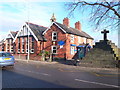
St John's Church of England Primary School
Situated on Delamere Street in the parish of Over. Next to the school is a cross - a 19th century lockup.
Image: © Eirian Evans
Taken: 12 Feb 2010
0.20 miles
2
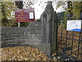
Church gatepost, Winsford
Stone gatepost at entrance to St John's Church, Winsford
Image: © Chris Cursley
Taken: 28 Oct 2016
0.24 miles
3
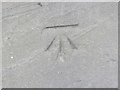
Winsford, Churchyard gatepost cut mark
OS benchmark found on stone post at entrance to St John's church, Winsford
Image: © Chris Cursley
Taken: 28 Oct 2016
0.24 miles