IMAGES TAKEN NEAR TO
Overway, WINSFORD, CW7 2BE
Introduction
This page details the photographs taken nearby to Overway, CW7 2BE by members of the Geograph project.
The Geograph project started in 2005 with the aim of publishing, organising and preserving representative images for every square kilometre of Great Britain, Ireland and the Isle of Man.

There are currently over 7.5m images from over14,400 individuals and you can help contribute to the project by visiting https://www.geograph.org.uk
Image Map
Images are licensed for reuse under creativecommons.org/licenses/by-sa/2.0
Notes
- Clicking on the map will re-center to the selected point.
- The higher the marker number, the further away the image location is from the centre of the postcode.
Image Listing (14 Images Found)
Images are licensed for reuse under creativecommons.org/licenses/by-sa/2.0
Image
Details
Distance
2
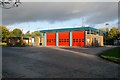
Winsford fire station
Winsford fire station, Sadler Road, Winsford, Cheshire.
Image: © Kevin Hale
Taken: 22 Oct 2006
0.14 miles
3
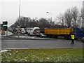
Police guidance for salt lorries
Police segregate waiting salt lorries from regular traffic as queueing lorries from all over the country join the 2.5km queue extending from the Salt Union rock salt mine on Bradford Road [SJ6568] up Winsford High Street at noon on Wednesday 7th January 2009. The coldest start to a New Year for over seven years.
Image: © Andrew Fielding
Taken: 7 Jan 2009
0.16 miles
4
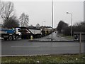
Queueing for salt
On 7 January 2009 the country was sufferring the coldest for 7 years. Temperatures dipped to -11 degrees C the queue to this point is 2.5km in length, not including the many lorries waiting inside the mine perimeter to be loaded with rock salt. Photograph is looking up Bradford Road with the River Weaver to the east.
Image: © Andrew Fielding
Taken: 7 Jan 2009
0.20 miles
5
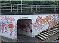
Subway under A54, Winsford
Welcome to Winsford, the calligraphic capital of Cheshire.
Image: © michael ely
Taken: 27 Jun 2006
0.20 miles
6
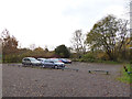
Car Park for the Whitegate Way
The car park is just off Bradford Road but is not well signed.
Image: © Stephen Craven
Taken: 18 Nov 2017
0.21 miles
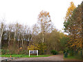
7
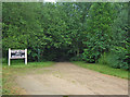
Whitegate Way, Winsford
This is the start/finish of the Whitegate Way, a permissive recreational route for walkers, horse riders and cyclists. It follows the line of an old salt-carrying railway line between Winsford and Cuddington (near Delamere Forest) that operated for almost one hundred years before closing in 1966. Here there is a car park off Bradford Road with a vandalized interpretation board. The sign to the left of shot marking the terminus appears to be one of the old station platform signs suitably annotated.
Image: © michael ely
Taken: 27 Jun 2006
0.23 miles
8
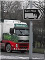
To the salt mine - Winsford - Cheshire
At the end of High Street, Winsford road signs direct traffic from the roundabout that crosses the River Weaver to the Meadowbank Mine on Bradford Road.
Image: © Andrew Fielding
Taken: 7 Jan 2009
0.23 miles
9
Eastern end of Whitegate Way
The route starts at the car park off Bradford Road Image
Image: © Stephen Craven
Taken: 18 Nov 2017
0.23 miles
10

Winsford Library
On the periphery of the Winsford Cross Centre.
Image: © John M
Taken: 3 May 2014
0.23 miles