IMAGES TAKEN NEAR TO
Stanthorne Drive, WINSFORD, CW7 1TR
Introduction
This page details the photographs taken nearby to Stanthorne Drive, CW7 1TR by members of the Geograph project.
The Geograph project started in 2005 with the aim of publishing, organising and preserving representative images for every square kilometre of Great Britain, Ireland and the Isle of Man.

There are currently over 7.5m images from over14,400 individuals and you can help contribute to the project by visiting https://www.geograph.org.uk
Image Map
Images are licensed for reuse under creativecommons.org/licenses/by-sa/2.0
Notes
- Clicking on the map will re-center to the selected point.
- The higher the marker number, the further away the image location is from the centre of the postcode.
Image Listing (16 Images Found)
Images are licensed for reuse under creativecommons.org/licenses/by-sa/2.0
Image
Details
Distance
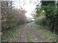
2
Stile & Footpath from Church Hill to Court House Farm
Image: © Dr Duncan Pepper
Taken: 15 Nov 2011
0.07 miles
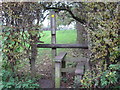
5
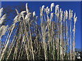
Pampas grass, St Chad's Churchyard, Winsford
Image: © Colin Park
Taken: 3 Feb 2015
0.18 miles
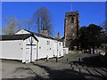
7
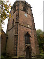
St Chad's Church Tower, Winsford
Churchyard is a shady spot under the trees.
Image
Image: © Chris Cursley
Taken: 28 Oct 2016
0.21 miles
8
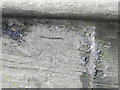
Winsford Church Cut Mark
OS benchmark found on the tower of St Chad's church, Winsford.
Image
Image: © Chris Cursley
Taken: 28 Oct 2016
0.21 miles

