IMAGES TAKEN NEAR TO
Peacock Avenue, WINSFORD, CW7 1TB
Introduction
This page details the photographs taken nearby to Peacock Avenue, CW7 1TB by members of the Geograph project.
The Geograph project started in 2005 with the aim of publishing, organising and preserving representative images for every square kilometre of Great Britain, Ireland and the Isle of Man.

There are currently over 7.5m images from over14,400 individuals and you can help contribute to the project by visiting https://www.geograph.org.uk
Image Map
Images are licensed for reuse under creativecommons.org/licenses/by-sa/2.0
Notes
- Clicking on the map will re-center to the selected point.
- The higher the marker number, the further away the image location is from the centre of the postcode.
Image Listing (3 Images Found)
Images are licensed for reuse under creativecommons.org/licenses/by-sa/2.0
Image
Details
Distance
1
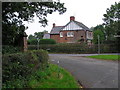
Darnhall Knobs, Winsford
Two stone pillars stand at the road junction known as Darnhall Knobs (Darnhall School Lane, Moors Lane, Hall Lane). A local web site describes the location...
"In 1897 to mark the celebration of Queen Victoria's Diamond Jubilee, one of the stone columns, which fell down 70 years previous, was re-erected at the Knobs. The bricks that were used, were taken from a cottage which was built two or three hundred years ago. This column was erected parallel to a similar one of very ancient date. In the base of the pillar, were placed newspapers giving an account of the opening of the Verdin Technical School, Northwich, by her grace the Duchess of Westminster." http://www.darnhall.org.uk/History.htm
Image: © Graham Shaw
Taken: 15 Oct 2006
0.24 miles
2
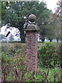
Stone Pillar, Darnhall Knobs
One of the stone pillars at Darnhall Knobs
Image: © Graham Shaw
Taken: 15 Oct 2006
0.24 miles
3
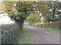
Track to Beech House Farm & Surrey Hall
Image: © Dr Duncan Pepper
Taken: 15 Nov 2011
0.24 miles