IMAGES TAKEN NEAR TO
Peregrine Close, WINSFORD, CW7 1SH
Introduction
This page details the photographs taken nearby to Peregrine Close, CW7 1SH by members of the Geograph project.
The Geograph project started in 2005 with the aim of publishing, organising and preserving representative images for every square kilometre of Great Britain, Ireland and the Isle of Man.

There are currently over 7.5m images from over14,400 individuals and you can help contribute to the project by visiting https://www.geograph.org.uk
Image Map
Images are licensed for reuse under creativecommons.org/licenses/by-sa/2.0
Notes
- Clicking on the map will re-center to the selected point.
- The higher the marker number, the further away the image location is from the centre of the postcode.
Image Listing (3 Images Found)
Images are licensed for reuse under creativecommons.org/licenses/by-sa/2.0
Image
Details
Distance
2
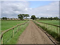
Farmers Road in Moors Lane Farm
The road (marked on the Explorer series) stretches from the farm buildings to the end of the farmers land in the neighbouring square Image The footpath across the field no longer takes the path shown on the map, due to the placement of an electric fence, so the footpath continues at a stile near the tree to the right of the road in the distance.
Image: © David Quinn
Taken: 27 Aug 2007
0.24 miles
3
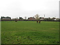
Equine Grazing Paddock at Grange Farm
Image: © Dr Duncan Pepper
Taken: 15 Nov 2011
0.24 miles