IMAGES TAKEN NEAR TO
Alamein Drive, WINSFORD, CW7 1DR
Introduction
This page details the photographs taken nearby to Alamein Drive, CW7 1DR by members of the Geograph project.
The Geograph project started in 2005 with the aim of publishing, organising and preserving representative images for every square kilometre of Great Britain, Ireland and the Isle of Man.

There are currently over 7.5m images from over14,400 individuals and you can help contribute to the project by visiting https://www.geograph.org.uk
Image Map
Images are licensed for reuse under creativecommons.org/licenses/by-sa/2.0
Notes
- Clicking on the map will re-center to the selected point.
- The higher the marker number, the further away the image location is from the centre of the postcode.
Image Listing (4 Images Found)
Images are licensed for reuse under creativecommons.org/licenses/by-sa/2.0
Image
Details
Distance
1
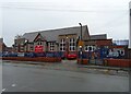
St. Chad's Church of England Primary and Nursery School
Image: © JThomas
Taken: 21 Mar 2024
0.15 miles
2
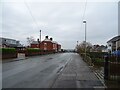
Gladstone Street, Winsford
Looking northeast down Gladstone Street towards the Weaver Valley. The housing here is ex-local authority stock probably built just after the second World War.
Image: © michael ely
Taken: 27 Jun 2006
0.18 miles
3
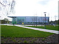
Winsford Lifestyle Centre
Located where the swimming baths used to be and next to Wyvern House.
Image: © Beryl Harwood
Taken: 8 Apr 2010
0.24 miles