IMAGES TAKEN NEAR TO
Springhill, TARPORLEY, CW6 9UL
Introduction
This page details the photographs taken nearby to Springhill, CW6 9UL by members of the Geograph project.
The Geograph project started in 2005 with the aim of publishing, organising and preserving representative images for every square kilometre of Great Britain, Ireland and the Isle of Man.

There are currently over 7.5m images from over14,400 individuals and you can help contribute to the project by visiting https://www.geograph.org.uk
Image Map
Images are licensed for reuse under creativecommons.org/licenses/by-sa/2.0
Notes
- Clicking on the map will re-center to the selected point.
- The higher the marker number, the further away the image location is from the centre of the postcode.
Image Listing (23 Images Found)
Images are licensed for reuse under creativecommons.org/licenses/by-sa/2.0
Image
Details
Distance
1
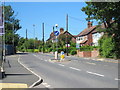
Nantwich Road, Tarporley
Looking north along the Nantwich Road as it enters Tarporley.
Image: © Jeff Buck
Taken: 22 Jun 2018
0.07 miles
2
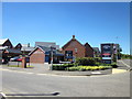
Haddington Park, Tarporley
Haddington Park, a new housing estate to the south of Tarporley on the Nantwich Road.
Image: © Jeff Buck
Taken: 22 Jun 2018
0.08 miles
3
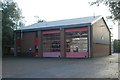
Tarporley fire station
Tarporley fire station, Birch Heath Road, Tarporley, Cheshire.
Image: © Kevin Hale
Taken: 22 Oct 2006
0.10 miles
5
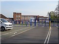
Tarporley High School
All locked up at the weekend.
Image: © Richard Webb
Taken: 30 Mar 2019
0.12 miles
6
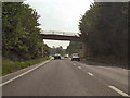
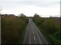
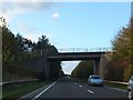
Birch Heath Road Bridge
Bridge carrying Birch Heath Road over the A49, at Tarporley.
Image: © David Dixon
Taken: 4 Sep 2010
0.12 miles

8
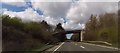
Birch Heath Road
Bridging the Tarporley Bypass (A49).
Image: © JThomas
Taken: 21 Mar 2024
0.12 miles
10
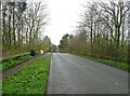
Bridge over A51at Birch Heath
One of the two roads out of Tarporley that are carried over the main road by bridges, reducing the number of junctions on the trunk roads such as the A51
Image: © David Smith
Taken: 19 Oct 2011
0.13 miles