IMAGES TAKEN NEAR TO
Plough Close, TARPORLEY, CW6 9LS
Introduction
This page details the photographs taken nearby to Plough Close, CW6 9LS by members of the Geograph project.
The Geograph project started in 2005 with the aim of publishing, organising and preserving representative images for every square kilometre of Great Britain, Ireland and the Isle of Man.

There are currently over 7.5m images from over14,400 individuals and you can help contribute to the project by visiting https://www.geograph.org.uk
Image Map
Images are licensed for reuse under creativecommons.org/licenses/by-sa/2.0
Notes
- Clicking on the map will re-center to the selected point.
- The higher the marker number, the further away the image location is from the centre of the postcode.
Image Listing (6 Images Found)
Images are licensed for reuse under creativecommons.org/licenses/by-sa/2.0
Image
Details
Distance
1
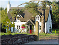
Thatched cottage, Tarporley
This cottage was extensively refurbished in the late 1990s but retains many original features
Image: © Alan Godfree
Taken: 22 Sep 2002
0.14 miles
3
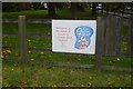
Farm sign, Tiresford
Yoghurt makers near Tarporley - Tiresford Guernsey Gold.
Image: © Richard Webb
Taken: 11 Oct 2017
0.23 miles
5
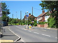
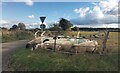
Nantwich Road, Tarporley
Looking north along the Nantwich Road as it enters Tarporley.
Image: © Jeff Buck
Taken: 22 Jun 2018
0.24 miles
6

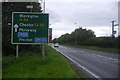
A49 - route confirmatory sign north of Four Lane Ends
Image: © Peter Whatley
Taken: 17 Jan 2012
0.25 miles