IMAGES TAKEN NEAR TO
Long Lane, TARPORLEY, CW6 9LH
Introduction
This page details the photographs taken nearby to Long Lane, CW6 9LH by members of the Geograph project.
The Geograph project started in 2005 with the aim of publishing, organising and preserving representative images for every square kilometre of Great Britain, Ireland and the Isle of Man.

There are currently over 7.5m images from over14,400 individuals and you can help contribute to the project by visiting https://www.geograph.org.uk
Image Map
Images are licensed for reuse under creativecommons.org/licenses/by-sa/2.0
Notes
- Clicking on the map will re-center to the selected point.
- The higher the marker number, the further away the image location is from the centre of the postcode.
Image Listing (3 Images Found)
Images are licensed for reuse under creativecommons.org/licenses/by-sa/2.0
Image
Details
Distance
1
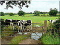
Cheshire dairy land
Looking south from Long Lane.
Image: © Jonathan Billinger
Taken: 7 Sep 2011
0.13 miles
2
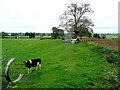
Cheshire dairy pasture
The placename strongly suggests the dominant land-use.
Image: © Jonathan Billinger
Taken: 7 Sep 2011
0.20 miles
3
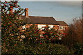
Farm Cottages near Alpraham Green
An attractive pair of farm cottages on a backroad near Alpraham Green, Cheshire. Holly in full berry between Christmas and New Year 2006.
Image: © Peter Styles
Taken: 28 Dec 2006
0.23 miles