IMAGES TAKEN NEAR TO
Nantwich Road, TARPORLEY, CW6 9JT
Introduction
This page details the photographs taken nearby to Nantwich Road, CW6 9JT by members of the Geograph project.
The Geograph project started in 2005 with the aim of publishing, organising and preserving representative images for every square kilometre of Great Britain, Ireland and the Isle of Man.

There are currently over 7.5m images from over14,400 individuals and you can help contribute to the project by visiting https://www.geograph.org.uk
Image Map
Images are licensed for reuse under creativecommons.org/licenses/by-sa/2.0
Notes
- Clicking on the map will re-center to the selected point.
- The higher the marker number, the further away the image location is from the centre of the postcode.
Image Listing (11 Images Found)
Images are licensed for reuse under creativecommons.org/licenses/by-sa/2.0
Image
Details
Distance
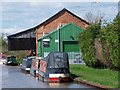
1
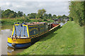
'Malvern' at Calveley
A splendid looking working narrowboat in British Waterways colours is moored on the Shropshire union Canal just east of Calveley service station.
Image: © Stephen McKay
Taken: 12 Sep 2013
0.03 miles
2
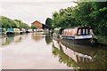
Shropshire Union Canal, Calveley
Looking east to Calveley Service Station on the Shropshire Union Canal
Image: © Pierre Terre
Taken: 20 May 2005
0.04 miles
3
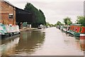
Shropshire Union Canal - Calveley Service station
Looking south east
Image: © Pierre Terre
Taken: 20 May 2005
0.04 miles
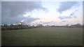
7
Grazing south east of Calveley
Looking towards the Shropshire Union Canal.
Image: © JThomas
Taken: 12 Nov 2016
0.16 miles
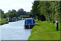
8
Calveley Service Station, Shropshire Union Canal
British Waterways services in old canal warehouse.
Image: © David Martin
Taken: 12 Apr 2012
0.17 miles
9
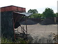
Coal Yard, Calveley
In Station Yard, beside the railway.
Image: © Eirian Evans
Taken: 4 Jul 2010
0.17 miles
10
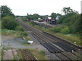
The Crewe-Chester railway line at Calveley
Part of a platform of the former station here is visible on the right - see http://www.disused-stations.org.uk/c/calveley/index.shtml for other photos and information on the station.
The surfaced areas of track are not part of a level crossing but are for Network Rail and its contractors to place or remove road/rail maintenance machines onto or from the track.
Image: © Eirian Evans
Taken: 4 Jul 2010
0.19 miles