IMAGES TAKEN NEAR TO
Chester Road, TARPORLEY, CW6 9EX
Introduction
This page details the photographs taken nearby to Chester Road, CW6 9EX by members of the Geograph project.
The Geograph project started in 2005 with the aim of publishing, organising and preserving representative images for every square kilometre of Great Britain, Ireland and the Isle of Man.

There are currently over 7.5m images from over14,400 individuals and you can help contribute to the project by visiting https://www.geograph.org.uk
Image Map
Images are licensed for reuse under creativecommons.org/licenses/by-sa/2.0
Notes
- Clicking on the map will re-center to the selected point.
- The higher the marker number, the further away the image location is from the centre of the postcode.
Image Listing (8 Images Found)
Images are licensed for reuse under creativecommons.org/licenses/by-sa/2.0
Image
Details
Distance

3
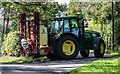
Moss Hall Farm
Tractor at Moss Hall Farm.
Image: © Peter McDermott
Taken: 24 Aug 2019
0.18 miles

7
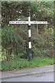
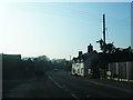
Direction Sign - Signpost by the A54, Chester Road, Little Budworth
Pawn finial - 3 arms; Cheshire CCC octagonal by the A54, in parish of Little Budworth (Vale Royal District), junction of Chester Road with Shop Lane.
Surveyed
Milestone Society National ID: CH_SJ5966
Image: © Milestone Society
Taken: Unknown
0.24 miles
8

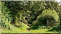
Beech Road
Looking through to Moss Hall Farm.
Image: © Richard Webb
Taken: 30 Mar 2019
0.25 miles