IMAGES TAKEN NEAR TO
Chester Road, TARPORLEY, CW6 0SP
Introduction
This page details the photographs taken nearby to Chester Road, CW6 0SP by members of the Geograph project.
The Geograph project started in 2005 with the aim of publishing, organising and preserving representative images for every square kilometre of Great Britain, Ireland and the Isle of Man.

There are currently over 7.5m images from over14,400 individuals and you can help contribute to the project by visiting https://www.geograph.org.uk
Image Map
Images are licensed for reuse under creativecommons.org/licenses/by-sa/2.0
Notes
- Clicking on the map will re-center to the selected point.
- The higher the marker number, the further away the image location is from the centre of the postcode.
Image Listing (18 Images Found)
Images are licensed for reuse under creativecommons.org/licenses/by-sa/2.0
Image
Details
Distance
1

Kelsall Lodge
Kelsall Lodge where the Sandstone Trail crosses the A556.
Image: © Sue Adair
Taken: 16 Apr 2006
0.01 miles
2

Kelsall Lodge
Outbuilding at Kelsall Lodge.
Image: © Peter McDermott
Taken: 24 Aug 2019
0.02 miles
3

Dog bowl, The Lodge
Beside the path and near the car park, a drinking bowl left by a considerate local. Must be popular on a warm day, there is little surface water on the porous Permian sandstone.
Image: © Richard Webb
Taken: 8 Aug 2010
0.03 miles
4

Old Milepost by the A54 on Kelsall Hill
Cast iron post by the A54, in parish of Crowton (Vale Royal District), Chester Road; 100m West of Kelsall Hill Tollhouse, in lay-by beside Sandstone Trail Car Park, on South side of road. Old domed open book, erected by the Northwich & Kelsall turnpike trust in the 19th century.
Inscription reads:-
: CHESTER 9 / KELSALL / 1 MILES : : NORTHWICH / 8½ MILES :
Oval plaque:-
: EDDISBURY / S+H / M :
Maker:-
: W H SMITH & CO / MAKERS / WHITCHURCH :
Grade II listed.
List Entry Number: 1139196 https://historicengland.org.uk/listing/the-list/list-entry/1139196
Milestone Society National ID: CH_CHNW09
Image: © A Rosevear
Taken: 17 May 2009
0.03 miles
5

Entrance to car park in Delamere Forest
Beside the A54, giving access to the forest walks
Image: © David Smith
Taken: 24 Oct 2019
0.04 miles
6

Tollhouse by the A54, Chester Road, Kelsall Hill, Kelsall
Tollhouse by the A54, in parish of Delamere (Vale Royal District), The Old Toll House, Chester Road, Kelsall Hill, Kelsall, CW6 0SP.
Grade II listed.
List Entry Number: 1139197 https://historicengland.org.uk/listing/the-list/list-entry/1139197
Surveyed
Milestone Society National ID: CH.DEL
Image: © Alan Rosevear
Taken: 17 May 2009
0.07 miles
7
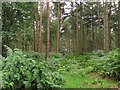
Conifers, Delamere Forest
Now linked to the main block of the forest by the planting of Hangingstone Hill. Pine woods with fern understorey.
Image: © Richard Webb
Taken: 8 Aug 2010
0.09 miles
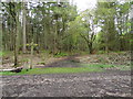
8

Conifers, Delamere
A thin strip of woodland to the south of the A54.
Image: © Richard Webb
Taken: 8 Aug 2010
0.09 miles
9

The A54 approach to the Sandstone Trail crossing at Gresty's Waste
Image: © Raymond Knapman
Taken: 26 Sep 2013
0.09 miles
10
Intersection of paths
Footpath crossing the Sandstone Trail.
Image: © Bryan Pready
Taken: 10 May 2012
0.10 miles