IMAGES TAKEN NEAR TO
Chester Road, TARPORLEY, CW6 0RZ
Introduction
This page details the photographs taken nearby to Chester Road, CW6 0RZ by members of the Geograph project.
The Geograph project started in 2005 with the aim of publishing, organising and preserving representative images for every square kilometre of Great Britain, Ireland and the Isle of Man.

There are currently over 7.5m images from over14,400 individuals and you can help contribute to the project by visiting https://www.geograph.org.uk
Image Map
Images are licensed for reuse under creativecommons.org/licenses/by-sa/2.0
Notes
- Clicking on the map will re-center to the selected point.
- The higher the marker number, the further away the image location is from the centre of the postcode.
Image Listing (19 Images Found)
Images are licensed for reuse under creativecommons.org/licenses/by-sa/2.0
Image
Details
Distance
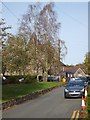
1
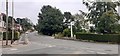
Junction in Kelsall
The junction of Hollands Lane and Chester Road, just outside the Co-op.
Image: © Mike Pennington
Taken: 15 Aug 2020
0.01 miles
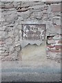
3
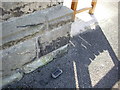
Cut Mark: Methodist Church, Kelsall
OS Cut Mark into the stone of the Methodist Church, Kelsall. Number B11125 on the Benchmark Database, see http://www.bench-marks.org.uk/bm37485
Image: © VBForever
Taken: 8 Apr 2011
0.05 miles
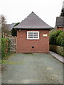
4
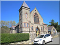
Kelsall Methodist Church
The Wesleyan Methodist Chapel in Kelsall was originally built in 1816 and rebuilt in 1884.
Image: © Jeff Buck
Taken: 19 Apr 2018
0.06 miles
6
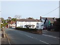
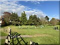
The Lord Binning, Kelsall
An inn and restaurant in the village.
Image: © David Smith
Taken: 20 Oct 2011
0.06 miles
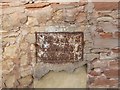
9
Old Milestone by the former A54, Chester Road, Kelsall
Metal plate attached to stone post by the UC road (was A54), in parish of Kelsall (Chester District), Chester Road, next to junction with Church Lane North, in wall, on North-east side of road. Erected by the Northwich & Kelsall Turnpike Trust in the 19th century.
Inscription reads:-
To
Chester 8
Northwich 9
Middlewich 1
Milestone Society National ID: CH_CHNW08a.
Image: © Milestone Society
Taken: 1 Aug 2017
0.13 miles
10
Iron "milestone" on Chester Road
Chester 8, Northwich 9, Middlewich 12; current routeplanners say that Chester is 9 miles away, Northwich 9.3, Middlewich 12.8. The context is shown inImage]
Image: © David Smith
Taken: 20 Oct 2011
0.13 miles