IMAGES TAKEN NEAR TO
Mallows Way, TARPORLEY, CW6 0RQ
Introduction
This page details the photographs taken nearby to Mallows Way, CW6 0RQ by members of the Geograph project.
The Geograph project started in 2005 with the aim of publishing, organising and preserving representative images for every square kilometre of Great Britain, Ireland and the Isle of Man.

There are currently over 7.5m images from over14,400 individuals and you can help contribute to the project by visiting https://www.geograph.org.uk
Image Map
Images are licensed for reuse under creativecommons.org/licenses/by-sa/2.0
Notes
- Clicking on the map will re-center to the selected point.
- The higher the marker number, the further away the image location is from the centre of the postcode.
Image Listing (5 Images Found)
Images are licensed for reuse under creativecommons.org/licenses/by-sa/2.0
Image
Details
Distance
1
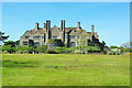
Tirley Garth
The south facade of the house
Image: © Kevin Waterhouse
Taken: 15 May 2016
0.04 miles
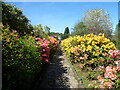
3
Former Kitchen Garden
At Tirley Garth with the bothy arched entrance beyond
Image: © Kevin Waterhouse
Taken: 15 May 2016
0.07 miles
4
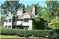
Tirley Cottage
On the Tirley Garth estate situated towards the northern entrance
Image: © Kevin Waterhouse
Taken: 15 May 2016
0.16 miles
5
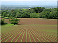
Striped landscape
Newly-planted crops above Tirley Garth.
Image: © John H Darch
Taken: 4 Jun 2020
0.23 miles