IMAGES TAKEN NEAR TO
Clemley Close, TARPORLEY, CW6 0RD
Introduction
This page details the photographs taken nearby to Clemley Close, CW6 0RD by members of the Geograph project.
The Geograph project started in 2005 with the aim of publishing, organising and preserving representative images for every square kilometre of Great Britain, Ireland and the Isle of Man.

There are currently over 7.5m images from over14,400 individuals and you can help contribute to the project by visiting https://www.geograph.org.uk
Image Map
Images are licensed for reuse under creativecommons.org/licenses/by-sa/2.0
Notes
- Clicking on the map will re-center to the selected point.
- The higher the marker number, the further away the image location is from the centre of the postcode.
Image Listing (6 Images Found)
Images are licensed for reuse under creativecommons.org/licenses/by-sa/2.0
Image
Details
Distance
1
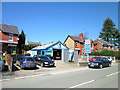
Kelsall Service Station, Chester Road
Kelsall Service Station on Chester Road.
Image: © Jeff Buck
Taken: 19 Apr 2018
0.15 miles
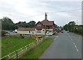
3
Bridge over A54 at Kelsall Hill
An unusually straight minor road passes over the A54 in the North of the square. The picture is taken from the bridge looking east.
Image: © Gary Rogers
Taken: 20 May 2005
0.19 miles
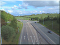
4
The A54 approach to the sliproad for Kelsall
Image: © Raymond Knapman
Taken: 26 Sep 2013
0.23 miles
5
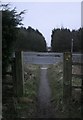
Road Crossing
Here the Eddisbury Way crosses the busy A54 care must be taken at this spot a very fast road indeed. When across it is just one more field and we are in Kelsall Village
Image: © Alan James
Taken: 22 Sep 2004
0.24 miles
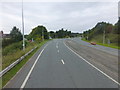
6
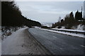
A54, Kelsall
From the footpath crossing below Kelsall Hill; the road drops from the mid-Cheshire ridge to the Dee valley. The village was bypassed in 1986.
Image: © Dave Dunford
Taken: 10 Jan 2010
0.24 miles