IMAGES TAKEN NEAR TO
Willington, TARPORLEY, CW6 0JT
Introduction
This page details the photographs taken nearby to CW6 0JT by members of the Geograph project.
The Geograph project started in 2005 with the aim of publishing, organising and preserving representative images for every square kilometre of Great Britain, Ireland and the Isle of Man.

There are currently over 7.5m images from over14,400 individuals and you can help contribute to the project by visiting https://www.geograph.org.uk
Image Map
Images are licensed for reuse under creativecommons.org/licenses/by-sa/2.0
Notes
- Clicking on the map will re-center to the selected point.
- The higher the marker number, the further away the image location is from the centre of the postcode.
Image Listing (9 Images Found)
Images are licensed for reuse under creativecommons.org/licenses/by-sa/2.0
Image
Details
Distance
1
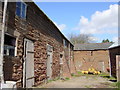
Outbuildings, Tirley Farm
Sandstone outbuildings at Tirley Farm near Utkinton
Image: © Sue Adair
Taken: 16 Apr 2006
0.05 miles
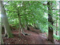
2

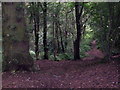
Woodland path near Tirley Farm, Utkinton.
Image: © Andrew Loughran
Taken: 19 May 2006
0.05 miles
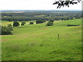
5
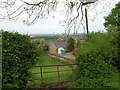
Countryside near Utkinton in Cheshire.
Rural scene looking north from Heath's Lane
Image: © Andrew Loughran
Taken: 19 May 2006
0.16 miles
6
Footpath to Abbeywood
This footpath skirts the eastern edge of Primrose Wood and Tirley Hollow heading north towards Abbeywood on the A54.
Image: © Jeff Buck
Taken: 6 Jul 2016
0.17 miles
7
The View from Tirley Hollow
Looking north-east from the footpath entrance to Tirley Hollow.
Image: © Jeff Buck
Taken: 6 Jul 2016
0.20 miles
8
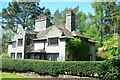
Tirley Cottage
On the Tirley Garth estate situated towards the northern entrance
Image: © Kevin Waterhouse
Taken: 15 May 2016
0.23 miles
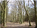
9

Tirlow Hollow
Woodland at Tirlow Hollow.
Image: © Peter McDermott
Taken: 24 Aug 2019
0.25 miles