IMAGES TAKEN NEAR TO
Stable Lane, TARPORLEY, CW6 0JL
Introduction
This page details the photographs taken nearby to Stable Lane, CW6 0JL by members of the Geograph project.
The Geograph project started in 2005 with the aim of publishing, organising and preserving representative images for every square kilometre of Great Britain, Ireland and the Isle of Man.

There are currently over 7.5m images from over14,400 individuals and you can help contribute to the project by visiting https://www.geograph.org.uk
Image Map
Images are licensed for reuse under creativecommons.org/licenses/by-sa/2.0
Notes
- Clicking on the map will re-center to the selected point.
- The higher the marker number, the further away the image location is from the centre of the postcode.
Image Listing (22 Images Found)
Images are licensed for reuse under creativecommons.org/licenses/by-sa/2.0
Image
Details
Distance
1
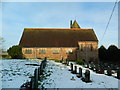
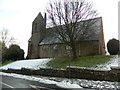
Church of St John & the Holy Cross, Cotebrook
Image: © John Lord
Taken: 31 Dec 2014
0.01 miles
2
Church of St John and the Holy Cross, Cotebrook
Image: © John Lord
Taken: 31 Dec 2014
0.01 miles
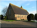
3

Church of St John and the Holy Cross, Cotebrook
Built 1874-5 by the prominent Victorian architect, G E Street.
Image: © John H Darch
Taken: 8 Aug 2021
0.02 miles
4
Church of St John and the Holy Cross, Cotebrook
Image: © John Lord
Taken: 31 Dec 2014
0.02 miles
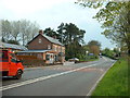
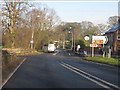
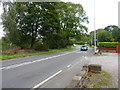
7

A49 - junction with the B5152, Cotebrook
Image: © Peter Whatley
Taken: 17 Jan 2012
0.08 miles