IMAGES TAKEN NEAR TO
Heatherways, TARPORLEY, CW6 0HP
Introduction
This page details the photographs taken nearby to Heatherways, CW6 0HP by members of the Geograph project.
The Geograph project started in 2005 with the aim of publishing, organising and preserving representative images for every square kilometre of Great Britain, Ireland and the Isle of Man.

There are currently over 7.5m images from over14,400 individuals and you can help contribute to the project by visiting https://www.geograph.org.uk
Image Map
Images are licensed for reuse under creativecommons.org/licenses/by-sa/2.0
Notes
- Clicking on the map will re-center to the selected point.
- The higher the marker number, the further away the image location is from the centre of the postcode.
Image Listing (11 Images Found)
Images are licensed for reuse under creativecommons.org/licenses/by-sa/2.0
Image
Details
Distance
2
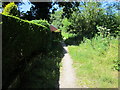
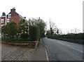
Footpath to Heath Green
Footpath heading north from Forest Road at the northern tip of Tarporley.
Image: © Jeff Buck
Taken: 22 Jun 2018
0.15 miles
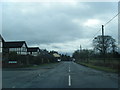
3
Forest Road, Tarporley
Looking northeast along Forest Road to the north of Tarporley.
Image: © Jeff Buck
Taken: 22 Jun 2018
0.17 miles
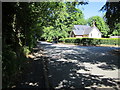
5
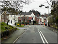
Tarporley, Rode Street/High Street
Tarporley is a large (population 2,614 at the 2011 Census) picturesque village on the west of the Cheshire Plain. It is believed that the High Street was part of a Roman Road called the Via Devana which ran from Chester to Colchester and the Domesday entry indicates that Tarporley was a small agricultural settlement in Norman times (http://www.tarporley.org.uk/about/history/ History of Tarporley). The village developed during the eighteenth and nineteenth centuries as it was on the route used by many traders travelling by coach between London and Chester and those dealing in salt mined in nearby Nantwich; it is now bypassed by the A49 and A51 roads (http://www.tarporley.net/main/about.htm About Tarporley).
Image: © David Dixon
Taken: 11 Apr 2016
0.18 miles
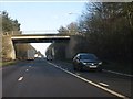
7
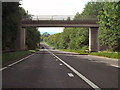
Utkinson Road Bridge
Bridge carrying Utkinson Road over the A49 at Tarporley.
Image: © David Dixon
Taken: 4 Sep 2010
0.22 miles
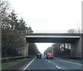
8
Utkinton Road overbridge, A49 Tarporley bypass
Image: © Peter Whatley
Taken: 17 Jan 2012
0.22 miles