IMAGES TAKEN NEAR TO
Platts Lane, TARPORLEY, CW6 0EU
Introduction
This page details the photographs taken nearby to Platts Lane, CW6 0EU by members of the Geograph project.
The Geograph project started in 2005 with the aim of publishing, organising and preserving representative images for every square kilometre of Great Britain, Ireland and the Isle of Man.

There are currently over 7.5m images from over14,400 individuals and you can help contribute to the project by visiting https://www.geograph.org.uk
Image Map
Images are licensed for reuse under creativecommons.org/licenses/by-sa/2.0
Notes
- Clicking on the map will re-center to the selected point.
- The higher the marker number, the further away the image location is from the centre of the postcode.
Image Listing (6 Images Found)
Images are licensed for reuse under creativecommons.org/licenses/by-sa/2.0
Image
Details
Distance
1
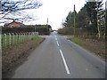
Road Junction at Duddon Heath
This peaceful country road junction is quite different from the A51, Chester to Nantwich road, which is just around the corner ahead.
Image: © John S Turner
Taken: 6 Feb 2007
0.05 miles
2
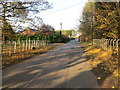
Junction of minor roads at Duddon Heath
Looking northward.
Image: © Peter Wood
Taken: 17 Nov 2018
0.07 miles
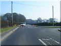
5
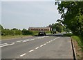
The A51 (south east) at Duddon Heath, Tarporley
The A51 at Duddon Heath heading southeast towards Tarporley.
Image: © Jeff Buck
Taken: 5 May 2007
0.11 miles
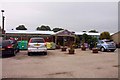
6
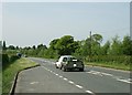
The A51 (north west) at Duddon Heath, Tarporley
Taken from the lay by near Okells Nurseries at Duddon Heath looking northwest towards Chester. Note the dead badger just behind the van and trailer.
Image: © Jeff Buck
Taken: 5 May 2007
0.16 miles