IMAGES TAKEN NEAR TO
Barracks Lane, NANTWICH, CW5 8PR
Introduction
This page details the photographs taken nearby to Barracks Lane, CW5 8PR by members of the Geograph project.
The Geograph project started in 2005 with the aim of publishing, organising and preserving representative images for every square kilometre of Great Britain, Ireland and the Isle of Man.

There are currently over 7.5m images from over14,400 individuals and you can help contribute to the project by visiting https://www.geograph.org.uk
Image Map
Images are licensed for reuse under creativecommons.org/licenses/by-sa/2.0
Notes
- Clicking on the map will re-center to the selected point.
- The higher the marker number, the further away the image location is from the centre of the postcode.
Image Listing (14 Images Found)
Images are licensed for reuse under creativecommons.org/licenses/by-sa/2.0
Image
Details
Distance
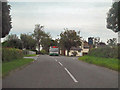
1
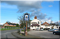
Farmer's Arms, Ravensmoor
The Farmer's Arms stands by the crossroads at the centre of the small village of Ravensmoor, opposite the village green (left). The red-brick semis (left background) are typical of the largely 1950s/60s housing in the village
Image: © Espresso Addict
Taken: 21 Feb 2007
0.05 miles
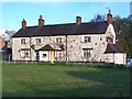
3
The Farmer's Arms, Ravensmoor
Looking across the village green to the pub.
Image: © Stephen McKay
Taken: 17 Jul 2018
0.07 miles
4
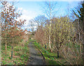
Spinners Wood, Ravensmoor
This small area of mixed woodland on the corner of Baddiley Lane and Sound Lane was planted by local volunteers led by Roy Aspinall in March 2000 to commemorate the millennium. There are several benches and gravel paths in amongst the young trees, which are predominantly oak, birch, hazel and holly. A plaque fixed to a large boulder in the south-east corner of the wood marks the event. In the distance, houses and part of the Farmer's Arms on Marsh Lane can be seen (centre left). [Note the position of Sound Lane on the 1:50,000 map appears incorrect compared with the 1:25,000]
Image: © Espresso Addict
Taken: 21 Feb 2007
0.08 miles
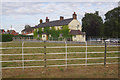
6
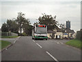
Farmers Arms, Ravensmoor Crossroads
Passing the Farmers Arms, at Ravensmoor Crossroads.
Image: © David Dixon
Taken: 4 Sep 2010
0.08 miles
8
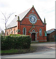
Baddiley & Ravensmoor Methodist Church
Orange-brick former Wesleyan Chapel dated 1878, located on Swanley Lane in Ravensmoor; now a Methodist church. The design, with the prominent circular window and topped pillars (the left is damaged), is slightly different from other former Wesleyan Chapels of similar dates in nearby villages such as Aston (see Image)
Image: © Espresso Addict
Taken: 21 Feb 2007
0.14 miles
9
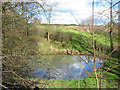
Small mere, near Edleston Brook
Small mere immediately north of Edleston Brook, visible from Sound Lane just outside Ravensmoor. On a subsequent visit in April 2010, this pleasant mere had been spoiled by the addition of decking. Image is immediately to the right of this view. [Note the position of the public house on the OS 1:50,000 which appears to be here is erroneous (it is actually located on Marsh Lane; see Image)]
Image: © Espresso Addict
Taken: 21 Feb 2007
0.15 miles
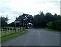
10
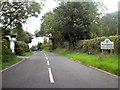
Ravensmoor
Baddiley Lane, entering Ravensmoor.
Image: © David Dixon
Taken: 4 Sep 2010
0.15 miles