IMAGES TAKEN NEAR TO
Long Lane, NANTWICH, CW5 8NE
Introduction
This page details the photographs taken nearby to Long Lane, CW5 8NE by members of the Geograph project.
The Geograph project started in 2005 with the aim of publishing, organising and preserving representative images for every square kilometre of Great Britain, Ireland and the Isle of Man.

There are currently over 7.5m images from over14,400 individuals and you can help contribute to the project by visiting https://www.geograph.org.uk
Image Map
Images are licensed for reuse under creativecommons.org/licenses/by-sa/2.0
Notes
- Clicking on the map will re-center to the selected point.
- The higher the marker number, the further away the image location is from the centre of the postcode.
Image Listing (2 Images Found)
Images are licensed for reuse under creativecommons.org/licenses/by-sa/2.0
Image
Details
Distance
1
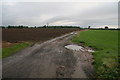
Permissive Bridleway, Burland Upper Green
Permissive bridleway running eastwards from Long Lane Burland Cheshire on a wet October morning.
Image: © Peter Styles
Taken: 20 Oct 2006
0.22 miles
2
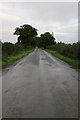
Long Lane ,Burland
Long Lane runs for several kilometres from Burland towards Radmore Green, Cheshire.
A typical Cheshire country road on a rainy October morning!
Image: © Peter Styles
Taken: 20 Oct 2006
0.22 miles