IMAGES TAKEN NEAR TO
Chester Road, NANTWICH, CW5 8LG
Introduction
This page details the photographs taken nearby to Chester Road, CW5 8LG by members of the Geograph project.
The Geograph project started in 2005 with the aim of publishing, organising and preserving representative images for every square kilometre of Great Britain, Ireland and the Isle of Man.

There are currently over 7.5m images from over14,400 individuals and you can help contribute to the project by visiting https://www.geograph.org.uk
Image Map
Images are licensed for reuse under creativecommons.org/licenses/by-sa/2.0
Notes
- Clicking on the map will re-center to the selected point.
- The higher the marker number, the further away the image location is from the centre of the postcode.
Image Listing (117 Images Found)
Images are licensed for reuse under creativecommons.org/licenses/by-sa/2.0
Image
Details
Distance
1
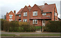
Semi-detached houses, Wilbraham Road, Acton
A small former council estate is located to the east of the A534 in Acton. It originally dates from the 1950s, but has been since extended with a mixture of semi-detached houses and terraced bungalows. In the background (left) is the Victorian School House on Chester Road. Formerly attached to Acton Church of England primary school, it is now private houses
Image: © Espresso Addict
Taken: 24 Feb 2008
0.03 miles
2
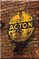
Old circular AA sign on the Chester Road in Acton
Old AA Sign located on a brick barn wall near the now closed Star Inn on the B5341 Chester Road in Acton, one mile northwest of Nantwich. Acton parish.
This is the Circular, village name on black band, no Motor Union symbol or name, type from 1923 showing distances Chester 19 Nantwich 1 London 163. Missing since at least 2005.
There were five series of AA signs, mostly dating from 1923 and made by Francis & Co / Franco in Deptford, London. The village name and distance to London or Dublin were normally displayed.
Milestone Society National ID: CH-ACT
Image: © Milestone Society
Taken: Unknown
0.05 miles
3
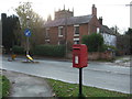
Elizabeth II postbox on Chester Road, Acton
Image: © JThomas
Taken: 12 Nov 2016
0.06 miles
4
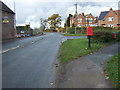
Chester Road, Acton
Looking north showing position of Postbox No. CW5 213.
See Image] for postbox.
Image: © JThomas
Taken: 12 Nov 2016
0.06 miles
5
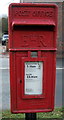
Close up, Elizabeth II postbox on Chester Road, Acton
Postbox No. CW5 213.
See Image] for wider view..
Image: © JThomas
Taken: 12 Nov 2016
0.06 miles
7
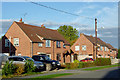
Housing in Acton, Cheshire
These mid-late twentieth century semi-detached houses are in Wilbraham Road.
Image: © Roger D Kidd
Taken: 20 Oct 2012
0.08 miles
8
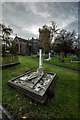
Hornby Grave, Acton, Nantwich
Albert Neilson Hornby, commonly designated A. N. Hornby, nicknamed Monkey Hornby (10 February 1847 in Blackburn, Lancashire – 17 December 1925 in Nantwich, Cheshire) was one of the best known sportsmen in England during the nineteenth century excelling in both rugby and cricket. He was the first of only two men to captain the country at both rugby and cricket but is also remembered as the England cricket captain whose side lost the Test match which gave rise to the Ashes, at home against the Australians in 1882. Additionally, he played football for Blackburn Rovers.
https://en.wikipedia.org/wiki/A._N._Hornby
Image: © Brian Deegan
Taken: 18 Nov 2017
0.08 miles
9

Chester Road, Acton
Chester Road (A534) passing through the village of Acton.
Image: © David Dixon
Taken: 4 Sep 2010
0.08 miles
10
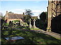
St Mary's churchyard, Acton
Looking across the churchyard of St Mary's towards the 17th century, Grade II listed almshouses. On the tower buttress at the right of the photo there is a bench mark - Image
Image: © John S Turner
Taken: 16 Oct 2009
0.09 miles