IMAGES TAKEN NEAR TO
Hollin Green Lane, NANTWICH, CW5 8JQ
Introduction
This page details the photographs taken nearby to Hollin Green Lane, CW5 8JQ by members of the Geograph project.
The Geograph project started in 2005 with the aim of publishing, organising and preserving representative images for every square kilometre of Great Britain, Ireland and the Isle of Man.

There are currently over 7.5m images from over14,400 individuals and you can help contribute to the project by visiting https://www.geograph.org.uk
Image Map
Images are licensed for reuse under creativecommons.org/licenses/by-sa/2.0
Notes
- Clicking on the map will re-center to the selected point.
- The higher the marker number, the further away the image location is from the centre of the postcode.
Image Listing (9 Images Found)
Images are licensed for reuse under creativecommons.org/licenses/by-sa/2.0
Image
Details
Distance
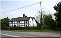
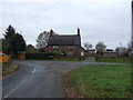
1
Roadside cottage
Roadside cottage near Hollin Green
Image: © Nigel Williams
Taken: 20 Feb 2006
0.01 miles
2
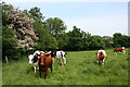
Inquisitive cows near Hollin Green
The area to the south of the A534 is a network of lanes and small pasture fields. An unnamed stream runs within the hedgerow (left). View from the public footpath from Hollin Green to the A534, at the path junction
Image: © Espresso Addict
Taken: 29 May 2008
0.13 miles
3
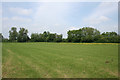
Pasture near Hollin Green
Large flat pasture field north of Hollin Green Lane. An unnamed stream runs along the hedgerow. View from the public footpath north from Hollin Green Lane
Image: © Espresso Addict
Taken: 29 May 2008
0.17 miles
4
Dragon's Cottage, Faddiley
This grade-II-listed black-and-white cottage on a bend on the busy A534 dates from the early 18th century, and has a flagpole in the garden. The track (right) is the public footpath to Hollin Green. For more information, see: http://www.imagesofengland.org.uk/details/default.aspx?id=56804
Image: © Espresso Addict
Taken: 29 May 2008
0.20 miles
6
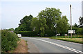
Bend in the A534 at Faddileybank
The A534 (Wrexham Road) is a busy A road running east-west from Wrexham to Nantwich. This view is by the junction with Willbank Lane, in the scattered settlement of Faddileybank
Image: © Espresso Addict
Taken: 29 May 2008
0.22 miles
7
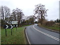
Road junction on Wrexham Road (A534), Faddiley
Looking west.
Image: © JThomas
Taken: 3 Dec 2016
0.22 miles
8
The Thatch Inn at Faddiley
Fourteenth century public house, cosy with atmosphere
Image: © John Naisbitt
Taken: 30 Nov 2005
0.25 miles
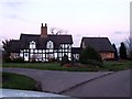
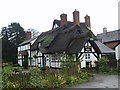
9

Newly thatched Thatch Inn, Faddiley
The grade-II-listed black-and-white inn on the A534 dates from the late 17th century, and was formerly the Tollemache Arms. For more information, see: http://www.imagesofengland.org.uk/details/default.aspx?id=56805
Image: © Espresso Addict
Taken: 29 May 2008
0.25 miles