IMAGES TAKEN NEAR TO
Woodhey Lane, NANTWICH, CW5 8JJ
Introduction
This page details the photographs taken nearby to Woodhey Lane, CW5 8JJ by members of the Geograph project.
The Geograph project started in 2005 with the aim of publishing, organising and preserving representative images for every square kilometre of Great Britain, Ireland and the Isle of Man.

There are currently over 7.5m images from over14,400 individuals and you can help contribute to the project by visiting https://www.geograph.org.uk
Image Map
Images are licensed for reuse under creativecommons.org/licenses/by-sa/2.0
Notes
- Clicking on the map will re-center to the selected point.
- The higher the marker number, the further away the image location is from the centre of the postcode.
Image Listing (3 Images Found)
Images are licensed for reuse under creativecommons.org/licenses/by-sa/2.0
Image
Details
Distance
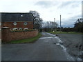
2
Cooks Pit Farm
Cooks Pit Farm, situated on a road junction near to Larden Green
Image: © Nigel Williams
Taken: 20 Feb 2006
0.04 miles
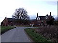
3
Cooks Pit Farm
Cooks Pit Farm stands opposite the junction of the Woodhey and Willbank lanes. The mixture of red brick and faux-Tudor black-and-white work as well as the prominent chimneys and hexagonal pattern in the windows are all typical features of buildings in South Cheshire. The adjacent barns (left of frame) are currently (August 2006) in the process of being converted into housing, also typical of this area
Image: © Espresso Addict
Taken: 3 Aug 2006
0.05 miles