IMAGES TAKEN NEAR TO
Hollyhurst Road, NANTWICH, CW5 8HT
Introduction
This page details the photographs taken nearby to Hollyhurst Road, CW5 8HT by members of the Geograph project.
The Geograph project started in 2005 with the aim of publishing, organising and preserving representative images for every square kilometre of Great Britain, Ireland and the Isle of Man.

There are currently over 7.5m images from over14,400 individuals and you can help contribute to the project by visiting https://www.geograph.org.uk
Image Map
Images are licensed for reuse under creativecommons.org/licenses/by-sa/2.0
Notes
- Clicking on the map will re-center to the selected point.
- The higher the marker number, the further away the image location is from the centre of the postcode.
Image Listing (5 Images Found)
Images are licensed for reuse under creativecommons.org/licenses/by-sa/2.0
Image
Details
Distance
1
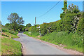
Pinsley Green
Near the railway bridge at Pinsley Green.
Image: © Wayland Smith
Taken: 5 Jun 2021
0.07 miles
2
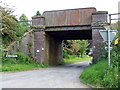
Railway bridge
A railway bridge near to Yew tree farm
Image: © Nigel Williams
Taken: 5 Jun 2006
0.08 miles
3
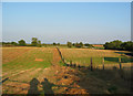
Hay fields south of Yew Tree Farm
Summer evening light on undulating farmland between Yew Tree Farm and Marley Hall
Image: © Espresso Addict
Taken: 7 Aug 2006
0.14 miles
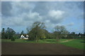
5
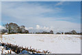
Stubble peeking through snow
View from near the junction between New Road and Pinsley Green Road, in the middle of the Pinsley Green hamlet, after an unusually heavy snowfall. This large field stretches most of the way up to the railway embankment (off picture to the right) and is usually used to grow maize.
Image: © Espresso Addict
Taken: 2 Mar 2006
0.22 miles