IMAGES TAKEN NEAR TO
New Road, NANTWICH, CW5 8HF
Introduction
This page details the photographs taken nearby to New Road, CW5 8HF by members of the Geograph project.
The Geograph project started in 2005 with the aim of publishing, organising and preserving representative images for every square kilometre of Great Britain, Ireland and the Isle of Man.

There are currently over 7.5m images from over14,400 individuals and you can help contribute to the project by visiting https://www.geograph.org.uk
Image Map
Images are licensed for reuse under creativecommons.org/licenses/by-sa/2.0
Notes
- Clicking on the map will re-center to the selected point.
- The higher the marker number, the further away the image location is from the centre of the postcode.
Image Listing (26 Images Found)
Images are licensed for reuse under creativecommons.org/licenses/by-sa/2.0
Image
Details
Distance
1
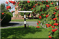
Wrenbury Village Green
A fingerpost is framed by rowan berries on Wrenbury's attractive village green.
Image: © Stephen McKay
Taken: 8 Sep 2013
0.06 miles
2
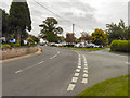
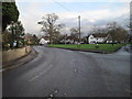
Village green, Wrenbury
The centre of Wrenbury village has a triangular village green by St Margaret's church (right). Elm House, one of several grade-II-listed 17th-century cottages in the village, stands on the junction of Cholmondeley Road (right) and New Lane (left)
Image: © Espresso Addict
Taken: 25 Jan 2007
0.06 miles
3
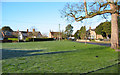
Wrenbury Green
The Green is being used as a car park for the church.
Image: © David Dixon
Taken: 4 Sep 2010
0.06 miles
4
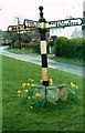
Old Direction Sign - Signpost in Wrenbury cum Frith, Cheshire
Pawn finial - 3 arms; Cheshire CCC octagonal by the UC road, in parish of Wrenbury cum Frith (Crewe and Nantwich District), Wrenbury Green at Nantwich Road junction with The Green and New Road.
Surveyed
Milestone Society National ID: CH_SJ5947B.
Image: © Milestone Society
Taken: 1 Mar 2004
0.07 miles
6
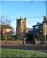
St Margaret's church tower, Wrenbury
The early-16th-century red-sandstone parish church dominates the village of Wrenbury. Here the tower is seen peeking between two residential buildings. View from the junction of New Lane and Cholmondeley Road
Image: © Espresso Addict
Taken: 25 Jan 2007
0.09 miles
8
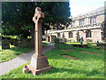
St Margaret's Graveyard and War Memorial
Wrenbury War Memorial, standing the Graveyard at St Margaret's Church.
Image: © David Dixon
Taken: 4 Sep 2010
0.09 miles
9
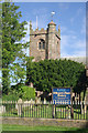
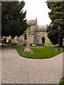
Wrenbury Church
St Margaret's Church was built in the 16th century although there have been later alterations and additions.
Image: © Stephen McKay
Taken: 8 Sep 2013
0.10 miles
10
St Margaret's Village Hall
Cholmodeley Road, Wrenbury Cum Frith.
Image: © David Dixon
Taken: 4 Sep 2010
0.10 miles