IMAGES TAKEN NEAR TO
CW5 8FZ
Introduction
This page details the photographs taken nearby to CW5 8FZ by members of the Geograph project.
The Geograph project started in 2005 with the aim of publishing, organising and preserving representative images for every square kilometre of Great Britain, Ireland and the Isle of Man.

There are currently over 7.5m images from over14,400 individuals and you can help contribute to the project by visiting https://www.geograph.org.uk
Image Map
Images are licensed for reuse under creativecommons.org/licenses/by-sa/2.0
Notes
- Clicking on the map will re-center to the selected point.
- The higher the marker number, the further away the image location is from the centre of the postcode.
Image Listing (6 Images Found)
Images are licensed for reuse under creativecommons.org/licenses/by-sa/2.0
Image
Details
Distance
3
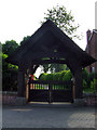
Aston church lych gate
The lych gate to the burial ground at Aston is on the opposite side of the road to the Church
Image: © Nigel Williams
Taken: 5 Jun 2006
0.17 miles
4
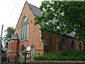
Aston Church
The church in Aston has its burial ground and lych gate on the opposite site of the road to the church
Image: © Nigel Williams
Taken: 5 Jun 2006
0.19 miles
5
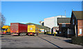
Aston Mill
The busy Aston Mill, an animal feed mill run by H J Lea Oakes Ltd, stands next to the church in the village of Aston (Image). It is one of the very few large industrial enterprises in this area and its warehouse building is visible for several miles
Image: © Espresso Addict
Taken: 14 Feb 2007
0.24 miles
6
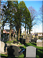
Aston Cemetery
This peaceful burial ground is set around 50m back from Wrenbury Road, accessed via a lych gate; it backs onto pasture on all four sides. Image (left) & Image (right), in Image, are visible in the distance
Image: © Espresso Addict
Taken: 14 Feb 2007
0.25 miles