IMAGES TAKEN NEAR TO
Second Dig Lane, NANTWICH, CW5 7QR
Introduction
This page details the photographs taken nearby to Second Dig Lane, CW5 7QR by members of the Geograph project.
The Geograph project started in 2005 with the aim of publishing, organising and preserving representative images for every square kilometre of Great Britain, Ireland and the Isle of Man.

There are currently over 7.5m images from over14,400 individuals and you can help contribute to the project by visiting https://www.geograph.org.uk
Image Map
Images are licensed for reuse under creativecommons.org/licenses/by-sa/2.0
Notes
- Clicking on the map will re-center to the selected point.
- The higher the marker number, the further away the image location is from the centre of the postcode.
Image Listing (3 Images Found)
Images are licensed for reuse under creativecommons.org/licenses/by-sa/2.0
Image
Details
Distance
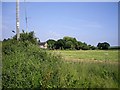
1
A529 towards Audlem
Viewed from the corner of First Dig Lane http://www.geograph.org.uk/photo/5236755
Audlem, Image a large village and civil parish in the unitary authority of Cheshire East, is about 7km ahead.
Image: © Jaggery
Taken: 13 Oct 2016
0.19 miles