IMAGES TAKEN NEAR TO
London Road, NANTWICH, CW5 7JW
Introduction
This page details the photographs taken nearby to London Road, CW5 7JW by members of the Geograph project.
The Geograph project started in 2005 with the aim of publishing, organising and preserving representative images for every square kilometre of Great Britain, Ireland and the Isle of Man.

There are currently over 7.5m images from over14,400 individuals and you can help contribute to the project by visiting https://www.geograph.org.uk
Image Map
Images are licensed for reuse under creativecommons.org/licenses/by-sa/2.0
Notes
- Clicking on the map will re-center to the selected point.
- The higher the marker number, the further away the image location is from the centre of the postcode.
Image Listing (7 Images Found)
Images are licensed for reuse under creativecommons.org/licenses/by-sa/2.0
Image
Details
Distance
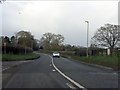
4
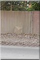
Old Milepost by the A51, London Road, Stapeley
Cast iron post by the A51, in parish of Stapeley (Crewe and Nantwich District), South of Stapeley House, on grass in front of wooden fence, on West side of road. Cast iron CCC1898, erected by the County Council in the 19th century.
Inscription reads:-
: NANTWICH / 2 MILES : : CHESHIRE / 1898 / COUNTY COUNCIL : : WALGHERTON / 2 MILES / WOORE / 7 :
Maker:-
: W H SMITH & CO / MAKERS / WHITCHURCH :
Milestone Society National ID: CH_NWWO02
Image: © J Higgins
Taken: 1 Mar 2004
0.14 miles
6
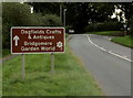
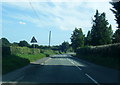
Brown direction sign alongside the A51 London Road, Stapeley
Ahead for Dagfields Crafts & Antiques and Bridgemere Garden World.
Image: © Jaggery
Taken: 13 Oct 2016
0.22 miles
7
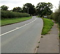
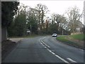
Grass strip between the A51 London Road and the pavement, Stapeley
Looking towards the grey back of this https://www.geograph.org.uk/photo/5873568 brown direction sign.
Image: © Jaggery
Taken: 13 Oct 2016
0.23 miles