IMAGES TAKEN NEAR TO
London Road, NANTWICH, CW5 7JS
Introduction
This page details the photographs taken nearby to London Road, CW5 7JS by members of the Geograph project.
The Geograph project started in 2005 with the aim of publishing, organising and preserving representative images for every square kilometre of Great Britain, Ireland and the Isle of Man.

There are currently over 7.5m images from over14,400 individuals and you can help contribute to the project by visiting https://www.geograph.org.uk
Image Map
Images are licensed for reuse under creativecommons.org/licenses/by-sa/2.0
Notes
- Clicking on the map will re-center to the selected point.
- The higher the marker number, the further away the image location is from the centre of the postcode.
Image Listing (18 Images Found)
Images are licensed for reuse under creativecommons.org/licenses/by-sa/2.0
Image
Details
Distance
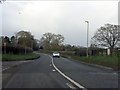
1
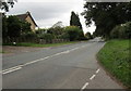
London Road, Stapeley
Looking to the SE along the A51 London Road from the corner of First Dig Lane.
Image: © Jaggery
Taken: 13 Oct 2016
0.03 miles
3
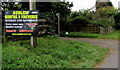
Audlem Bonfire & Fireworks notice in Stapeley
Alongside the A51 London Road near the First Dig Lane junction viewed on October 13th 2016. Gates open at 4pm on Sunday November 6th 2016. The bonfire will be lit at 6:30pm. There will be fairground rides and food stalls. Admission £5 - free entrance for the under fives.
Image: © Jaggery
Taken: 13 Oct 2016
0.06 miles
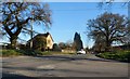
4
Junction of First Dig Lane and London Road, Stapeley
Viewed across the A51 London Road. First Dig Lane leads to the A529 about 500 metres ahead.
About 650 metres to the SE (left), Second Dig Lane also leads from the A51 to the A529.
Image: © Jaggery
Taken: 13 Oct 2016
0.07 miles
5
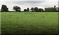
Grazing sheep in a Stapeley field
Viewed from First Dig Lane on the approach to the A51 London Road.
Image: © Jaggery
Taken: 13 Oct 2016
0.09 miles
6
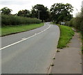
Grass strip between the A51 London Road and the pavement, Stapeley
Looking towards the grey back of this https://www.geograph.org.uk/photo/5873568 brown direction sign.
Image: © Jaggery
Taken: 13 Oct 2016
0.09 miles
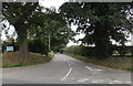
7
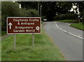
Brown direction sign alongside the A51 London Road, Stapeley
Ahead for Dagfields Crafts & Antiques and Bridgemere Garden World.
Image: © Jaggery
Taken: 13 Oct 2016
0.10 miles
9
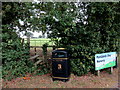
Stile and bin, First Dig Lane near Stapeley
The dual purpose bin is for litter and dog waste.
The entrance http://www.geograph.org.uk/photo/5236792 to Parklands Day Nursery is to the right of the name sign.
Image: © Jaggery
Taken: 13 Oct 2016
0.13 miles
10
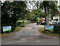
Entrance to Parklands Day Nursery near Stapeley
From First Dig Lane, accessed from the A51 London Road or the A529 Broad Lane.
Image: © Jaggery
Taken: 13 Oct 2016
0.13 miles