IMAGES TAKEN NEAR TO
Audlem Road, NANTWICH, CW5 7EB
Introduction
This page details the photographs taken nearby to Audlem Road, CW5 7EB by members of the Geograph project.
The Geograph project started in 2005 with the aim of publishing, organising and preserving representative images for every square kilometre of Great Britain, Ireland and the Isle of Man.

There are currently over 7.5m images from over14,400 individuals and you can help contribute to the project by visiting https://www.geograph.org.uk
Image Map
Images are licensed for reuse under creativecommons.org/licenses/by-sa/2.0
Notes
- Clicking on the map will re-center to the selected point.
- The higher the marker number, the further away the image location is from the centre of the postcode.
Image Listing (33 Images Found)
Images are licensed for reuse under creativecommons.org/licenses/by-sa/2.0
Image
Details
Distance
1
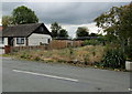
Fenced-off site on the west side of Audlem Road, Nantwich
Viewed in October 2016 view. A July 2011 Google Earth Street View
shows a bungalow here, similar to the one on the left.
Image: © Jaggery
Taken: 13 Oct 2016
0.01 miles
2
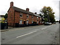
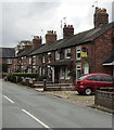
Row of brick houses, Audlem Road, Nantwich
Immediately south of Broad Lane Methodist Church. http://www.geograph.org.uk/photo/5153847
Image: © Jaggery
Taken: 13 Oct 2016
0.01 miles
3
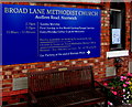
Information board and memorial bench, Broad Lane Methodist Church, Nantwich
Located here. http://www.geograph.org.uk/photo/5153847 The inscription on the plaque on the bench is
In Loving Memory of JOYCE & BRIAN HODGKISS Members Of This Chapel.
Image: © Jaggery
Taken: 13 Oct 2016
0.01 miles
4
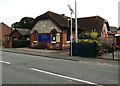
Broad Lane Methodist Church, Nantwich
Part of the Cheshire South Methodist Circuit, viewed across the A529 Audlem Road.
The church building dates from 1863.
Image: © Jaggery
Taken: 13 Oct 2016
0.02 miles
5

Queen Elizabeth II postbox and BT phonebox, Audlem Road, Nantwich
On the east side of the A529 Audlem Road in the south of Nantwich.
Image: © Jaggery
Taken: 13 Oct 2016
0.03 miles
6

Queen Elizabeth II postbox and two bins, Audlem Road, Nantwich
The bin on the left is for dog waste. Text on the litter bin on the right is
Crewe & Nantwich - Please Keep The Borough Tidy.
Image: © Jaggery
Taken: 13 Oct 2016
0.03 miles
7
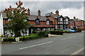
Housing variety, Audlem Road, Nantwich
On the west side of the A529 Audlem Road.
Image: © Jaggery
Taken: 13 Oct 2016
0.04 miles
8
Row of houses on the west side of Audlem Road, Nantwich
Looking towards a former turnpike tollhouse http://www.geograph.org.uk/photo/5153924 at the left edge of the photo.
Image: © Jaggery
Taken: 13 Oct 2016
0.04 miles
9
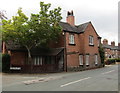
Tollgate House, Audlem Road, Nantwich
Former turnpike tollhouse on the corner of Audlem Road and Batherton Lane in the south of Nantwich.
Image: © Jaggery
Taken: 13 Oct 2016
0.05 miles
10
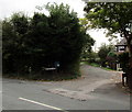
Batherton Lane, Nantwich
Dead-end lane viewed across the A529 Audlem Road.
Image: © Jaggery
Taken: 13 Oct 2016
0.05 miles