IMAGES TAKEN NEAR TO
Windsor Avenue, NANTWICH, CW5 7DN
Introduction
This page details the photographs taken nearby to Windsor Avenue, CW5 7DN by members of the Geograph project.
The Geograph project started in 2005 with the aim of publishing, organising and preserving representative images for every square kilometre of Great Britain, Ireland and the Isle of Man.

There are currently over 7.5m images from over14,400 individuals and you can help contribute to the project by visiting https://www.geograph.org.uk
Image Map
Images are licensed for reuse under creativecommons.org/licenses/by-sa/2.0
Notes
- Clicking on the map will re-center to the selected point.
- The higher the marker number, the further away the image location is from the centre of the postcode.
Image Listing (37 Images Found)
Images are licensed for reuse under creativecommons.org/licenses/by-sa/2.0
Image
Details
Distance
1
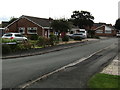
Windsor Avenue bungalows, Nantwich
Viewed from the corner of Delamere Road.
Image: © Jaggery
Taken: 13 Oct 2016
0.02 miles
2
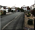
St Albans Drive, Nantwich
Cul-de-sac on the south side of Delamere Road.
Image: © Jaggery
Taken: 13 Oct 2016
0.04 miles
3
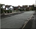
Southern end of Brown Avenue, Nantwich
Viewed from the corner of Marlowe Drive.
Image: © Jaggery
Taken: 13 Oct 2016
0.05 miles
4
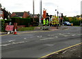
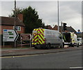
Wait here until green light shows, Audlem Road, Nantwich
During roadworks in October 2016, the permanent traffic lights at the A529/A530 junction
have been turned off and covered with hoods, and replaced by temporary traffic lights.
Image: © Jaggery
Taken: 13 Oct 2016
0.05 miles
5
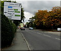
Direction signs facing Audlem Road, Nantwich
Near the A529/A530 junction, go right on the A530 for Dagfields Crafts & Antiques and Bridgemere Garden World. Also go right for Crewe, Stoke-on-Trent, Chester, Wrexham.
Image: © Jaggery
Taken: 13 Oct 2016
0.06 miles
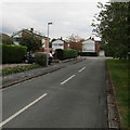
6
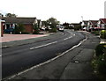
Bend in Delamere Road, Nantwich
East of the Mayflower Road junction.
Image: © Jaggery
Taken: 13 Oct 2016
0.06 miles
7
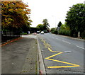
Zigzag yellow road marking, Audlem Road, Nantwich
Marking the Keep Clear Zone (no parking or stopping) outside Brine Leas School.
Image: © Jaggery
Taken: 13 Oct 2016
0.06 miles
8
Audlem Road directions sign, Nantwich
Facing the A530 Audlem Road on the approach to the A529 junction.
Image: © Jaggery
Taken: 13 Oct 2016
0.07 miles
9
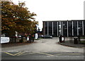
Entrance to Brine Leas School, Nantwich
From the A530 Audlem Road. The school is an academy specialising in technology and languages.
The banner on the left shows EVENING CLASSES HERE.
Image: © Jaggery
Taken: 13 Oct 2016
0.07 miles
10
East along Marlowe Drive, Nantwich
From the corner of Delamere Road along Marlowe Drive towards Brown Avenue.
Image: © Jaggery
Taken: 13 Oct 2016
0.08 miles