IMAGES TAKEN NEAR TO
Jan Palach Avenue, NANTWICH, CW5 7DJ
Introduction
This page details the photographs taken nearby to Jan Palach Avenue, CW5 7DJ by members of the Geograph project.
The Geograph project started in 2005 with the aim of publishing, organising and preserving representative images for every square kilometre of Great Britain, Ireland and the Isle of Man.

There are currently over 7.5m images from over14,400 individuals and you can help contribute to the project by visiting https://www.geograph.org.uk
Image Map
Images are licensed for reuse under creativecommons.org/licenses/by-sa/2.0
Notes
- Clicking on the map will re-center to the selected point.
- The higher the marker number, the further away the image location is from the centre of the postcode.
Image Listing (29 Images Found)
Images are licensed for reuse under creativecommons.org/licenses/by-sa/2.0
Image
Details
Distance
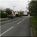
1
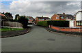
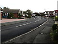
Jan Palach Avenue, Nantwich
The southern end of Jan Palach Avenue viewed from Brown Avenue. The avenue was named in memory of Jan Palach (1948–1969), a Czech student who set himself on fire in Wenceslas Square Prague on January 16th 1969 as a political protest against the end of the Prague Spring after the invasion of Czechoslovakia by the Warsaw Pact armies in 1968. He died on January 19th 1969. According to one online source, this is the only street so named in the UK.
Image: © Jaggery
Taken: 13 Oct 2016
0.04 miles
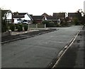
2
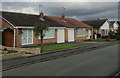
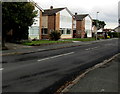
Brown Avenue bungalows, Nantwich
Originally, bungalow was used in English for a lightly-built house, with a veranda and one storey.
In current UK usage it is a convenient word for any one-storey dwelling.
Image: © Jaggery
Taken: 13 Oct 2016
0.06 miles
3
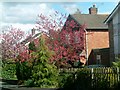
Cherry Blossom
Spring time in the neighbourhood.
Image: © Caroline Hampton
Taken: 15 Mar 2008
0.08 miles
4
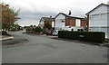
Brown Avenue, Nantwich
From the corner of Marlowe Drive. The Brown Avenue name sign is in the hedge on the right.
Image: © Jaggery
Taken: 13 Oct 2016
0.08 miles
5
East along Marlowe Drive, Nantwich
From the corner of Delamere Road along Marlowe Drive towards Brown Avenue.
Image: © Jaggery
Taken: 13 Oct 2016
0.10 miles
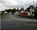
6
Southern end of Brown Avenue, Nantwich
Viewed from the corner of Marlowe Drive.
Image: © Jaggery
Taken: 13 Oct 2016
0.14 miles
7
Mayflower Road, Nantwich
On the north side of Delamere Road.
Image: © Jaggery
Taken: 13 Oct 2016
0.15 miles
8
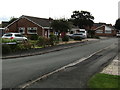
Windsor Avenue bungalows, Nantwich
Viewed from the corner of Delamere Road.
Image: © Jaggery
Taken: 13 Oct 2016
0.16 miles
9
Bend in Delamere Road, Nantwich
East of the Mayflower Road junction.
Image: © Jaggery
Taken: 13 Oct 2016
0.17 miles
10
Delamere Road, Nantwich
This part of Delamere Road is between Audlem Road and Mayflower Road.
Image: © Jaggery
Taken: 13 Oct 2016
0.19 miles