IMAGES TAKEN NEAR TO
Wellington Road, NANTWICH, CW5 7DA
Introduction
This page details the photographs taken nearby to Wellington Road, CW5 7DA by members of the Geograph project.
The Geograph project started in 2005 with the aim of publishing, organising and preserving representative images for every square kilometre of Great Britain, Ireland and the Isle of Man.

There are currently over 7.5m images from over14,400 individuals and you can help contribute to the project by visiting https://www.geograph.org.uk
Image Map (65 Images)


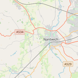

Leaflet Map data © OpenStreetMap
Images are licensed for reuse under creativecommons.org/licenses/by-sa/2.0
Notes
- Clicking on the map will re-center to the selected point.
- The higher the marker number, the further away the image location is from the centre of the postcode.
Image Listing (65 Images Found)
Images are licensed for reuse under creativecommons.org/licenses/by-sa/2.0
Image
Details
Distance
1
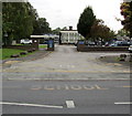
School entrance from Wellington Road, Nantwich
St Anne's Catholic Primary School is set back from the west side of Wellington Road.
Image: © Jaggery
Taken: 13 Oct 2016
0.04 miles
2
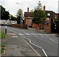
Zebra crossing, Wellington Road, Nantwich
The crossing is between the entrance to St Anne's Catholic Primary School and the Park Road junction (ahead). Viewed in October 2016. There was no crossing here in an August 2011 Google Earth Street View.
Image: © Jaggery
Taken: 13 Oct 2016
0.05 miles
3
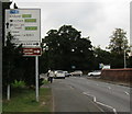
Directions sign facing Wellington Road, Nantwich
On the approach to the A530 junction, the sign is alongside the B5341 near its southern end.
Its northern end is about 4km away, at the Burford crossroads.
Image: © Jaggery
Taken: 13 Oct 2016
0.06 miles
4

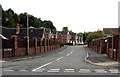
Parkfield Drive, Nantwich
On the east side of the B5341 Wellington Road.
Image: © Jaggery
Taken: 13 Oct 2016
0.06 miles
5
Tanners Way, Nantwich
Cul-de-sac on the west side of the B5341 Wellington Road.
Image: © Jaggery
Taken: 13 Oct 2016
0.07 miles
6
Mayflower Road, Nantwich
On the north side of Delamere Road.
Image: © Jaggery
Taken: 13 Oct 2016
0.08 miles
7
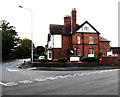
Atherton & Associates Wealth Management Ltd, Nantwich
Office at 1 Park Road, on the corner of Wellington Road.
Image: © Jaggery
Taken: 13 Oct 2016
0.08 miles
8
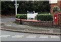
King George V wall postbox on a Nantwich corner
Located here http://www.geograph.org.uk/photo/5173244 on the corner of Wellington Road and Park Road. The GR on the box is short for Georgius Rex, Latin for King George, in this case King George V who reigned from May 1910-January 1936.
Image: © Jaggery
Taken: 13 Oct 2016
0.08 miles
9
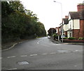
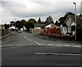
West along Park Road, Nantwich
The A530 Park Road viewed from the southern end of the B5341 Wellington Road.
Image: © Jaggery
Taken: 13 Oct 2016
0.09 miles
10
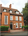
Geometric patterns at The Limes
The stairwell window is a particularly large example of the metal-framed windows in geometric patterns that are common in this area of Cheshire. Now a B&B, The Limes is named for the Image
Image: © Espresso Addict
Taken: 3 Oct 2006
0.11 miles