IMAGES TAKEN NEAR TO
Stonebridge Road, NANTWICH, CW5 7AY
Introduction
This page details the photographs taken nearby to Stonebridge Road, CW5 7AY by members of the Geograph project.
The Geograph project started in 2005 with the aim of publishing, organising and preserving representative images for every square kilometre of Great Britain, Ireland and the Isle of Man.

There are currently over 7.5m images from over14,400 individuals and you can help contribute to the project by visiting https://www.geograph.org.uk
Image Map
Images are licensed for reuse under creativecommons.org/licenses/by-sa/2.0
Notes
- Clicking on the map will re-center to the selected point.
- The higher the marker number, the further away the image location is from the centre of the postcode.
Image Listing (33 Images Found)
Images are licensed for reuse under creativecommons.org/licenses/by-sa/2.0
Image
Details
Distance
4
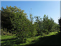
Coed Wen Community Woodland (north end)
A notice board on site explains that Coed Wen is Welsh for "white wood" - although this is in England it is near enough the border for there to be Welsh influence. It was planted by volunteers in 2004, so the trees are just over ten years old now. Dominant species are oak, ash, hazel and alder although there are a few evergreens as well.
Image: © Stephen Craven
Taken: 27 Sep 2015
0.15 miles
5
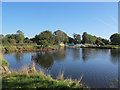
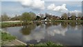
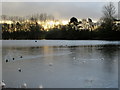
North end of Nantwich Lake
The lake, adjacent to the River Weaver, was created in 1975.
Photo taken from the Riverside Loop walk.
Image: © Stephen Craven
Taken: 27 Sep 2015
0.15 miles

7
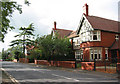
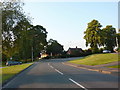
Park Road, South Nantwich
The large red-brick houses on the north side of Park Road are typical of the older houses in this area of south Nantwich. The pleasant street is lined with trees (out of frame on left), but being part of the A530 is heavily used
Image: © Espresso Addict
Taken: 3 Oct 2006
0.16 miles
8
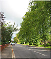
Limes lining Park Road
A mature row of limes line the A530 on the main route into Nantwich from the south. The street appears quiet, but is often busy with lorries and tractors
Image: © Espresso Addict
Taken: 3 Oct 2006
0.16 miles
9
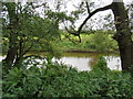
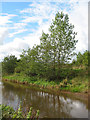
A glimpse of the River Weaver
Just South of Nantwich Lake.
Image: © John H Darch
Taken: 10 Oct 2019
0.16 miles
10
Willows by the River Weaver
The River Weaver is a placid meandering stream to the south west of Nantwich. Here the river leaves behind pastureland to run through a small boggy area adjacent to Shrewbridge Road
Image: © Espresso Addict
Taken: 3 Oct 2006
0.16 miles