IMAGES TAKEN NEAR TO
CW5 6YA
Introduction
This page details the photographs taken nearby to CW5 6YA by members of the Geograph project.
The Geograph project started in 2005 with the aim of publishing, organising and preserving representative images for every square kilometre of Great Britain, Ireland and the Isle of Man.

There are currently over 7.5m images from over14,400 individuals and you can help contribute to the project by visiting https://www.geograph.org.uk
Image Map
Images are licensed for reuse under creativecommons.org/licenses/by-sa/2.0
Notes
- Clicking on the map will re-center to the selected point.
- The higher the marker number, the further away the image location is from the centre of the postcode.
Image Listing (14 Images Found)
Images are licensed for reuse under creativecommons.org/licenses/by-sa/2.0
Image
Details
Distance
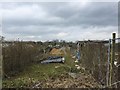
1
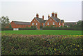
Henhull Farm, near Nantwich
Large red-brick dairy farm, situated north west of Nantwich. View from Welshmen's Lane
Image: © Espresso Addict
Taken: 16 Oct 2006
0.07 miles
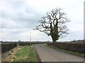
2
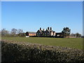
Henhull Hall near Nantwich
It was in this area that saw much of the action during the Civil War battle on or about the 25th January 1644.
Image: © Colin Park
Taken: 7 Mar 2010
0.07 miles
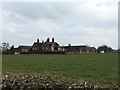
4
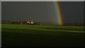
Rainbow towards Henhull Hall near Nantwich
Image: © Colin Park
Taken: 28 Jan 2017
0.08 miles
6
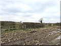
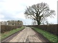
Footpath off Welshmen's Lane
Northern terminus of Henhull FP3. The path is diverted around rather than across the maize field.
Image: © Jonathan Hutchins
Taken: 15 Mar 2015
0.10 miles
8
Nantwich: Welshmen's Lane allotments
Image: © Jonathan Hutchins
Taken: 15 Mar 2015
0.17 miles
9
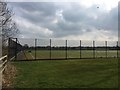
Malbank School & Sixth Form College sports facilities
Image: © Jonathan Hutchins
Taken: 15 Mar 2015
0.17 miles