IMAGES TAKEN NEAR TO
Middlewich Road, NANTWICH, CW5 6PH
Introduction
This page details the photographs taken nearby to Middlewich Road, CW5 6PH by members of the Geograph project.
The Geograph project started in 2005 with the aim of publishing, organising and preserving representative images for every square kilometre of Great Britain, Ireland and the Isle of Man.

There are currently over 7.5m images from over14,400 individuals and you can help contribute to the project by visiting https://www.geograph.org.uk
Image Map
Images are licensed for reuse under creativecommons.org/licenses/by-sa/2.0
Notes
- Clicking on the map will re-center to the selected point.
- The higher the marker number, the further away the image location is from the centre of the postcode.
Image Listing (24 Images Found)
Images are licensed for reuse under creativecommons.org/licenses/by-sa/2.0
Image
Details
Distance
1
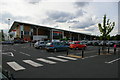
Sainsbury's superstore, Nantwich
Image: © Christopher Hilton
Taken: 26 May 2014
0.01 miles
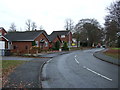
3
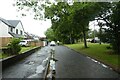
Bus stop and shelter on Middlewich Road (B5334)
Image: © JThomas
Taken: 3 Dec 2016
0.10 miles
4
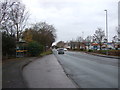
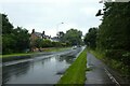
Cycle path along Middlewich Road
Part of National Cycle Network route 451.
Image: © DS Pugh
Taken: 6 Aug 2023
0.10 miles
5
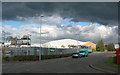
Storm clouds over Beam Heath Way
This area, formerly part of Barony Hospital, now houses builders' merchants, DIY stores and warehouses. Sainsbury's supermarket is just out of view (beyond trees, right of frame)
Image: © Espresso Addict
Taken: 2 Oct 2006
0.13 miles
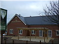
7
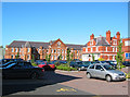
Frederick and Charles Houses, Princes Court
Two of a group of Victorian/Edwardian red-brick buildings in the north of Nantwich, formerly part of Barony Hospital. Frederick House (left) dates from 1891 and was used as an infirmary; Charles House (right) dates from 1905 and was used as a nursing home. The buildings have now been redeveloped as office space. For more details: http://www.workhouses.org.uk/index.html?Nantwich/Nantwich.shtml
Image: © Espresso Addict
Taken: 9 Oct 2006
0.16 miles
8
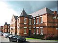
Frederick House, Princes Court
One of a group of Victorian/Edwardian red-brick buildings in the north of Nantwich, formerly part of Barony Hospital, which was built adjacent to the older Barony Workhouse. The buildings have now been redeveloped as office space. Frederick House dates from 1891, and its style is typical of many buildings of this period in the town. For more details: http://users.ox.ac.uk/~peter/workhouse/Nantwich/Nantwich.shtml
Image: © Espresso Addict
Taken: 2 Oct 2006
0.16 miles
9
Cycle path near Alvaston Roundabout
Looking along Middlewich Road. The path is part of National Cycle Network route 451.
Image: © DS Pugh
Taken: 6 Aug 2023
0.17 miles
10
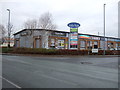
The Sacred Orchard
New public house on the A51
Image: © JThomas
Taken: 3 Dec 2016
0.17 miles