IMAGES TAKEN NEAR TO
London Road, NANTWICH, CW5 6LN
Introduction
This page details the photographs taken nearby to London Road, CW5 6LN by members of the Geograph project.
The Geograph project started in 2005 with the aim of publishing, organising and preserving representative images for every square kilometre of Great Britain, Ireland and the Isle of Man.

There are currently over 7.5m images from over14,400 individuals and you can help contribute to the project by visiting https://www.geograph.org.uk
Image Map
Images are licensed for reuse under creativecommons.org/licenses/by-sa/2.0
Notes
- Clicking on the map will re-center to the selected point.
- The higher the marker number, the further away the image location is from the centre of the postcode.
Image Listing (76 Images Found)
Images are licensed for reuse under creativecommons.org/licenses/by-sa/2.0
Image
Details
Distance
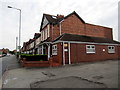
1
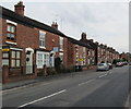
London Road houses, Nantwich
Houses on the north side of the B5074 London Road viewed looking away from the town centre.
Image: © Jaggery
Taken: 13 Oct 2016
0.02 miles
2

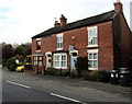
London Road house with a shop-style frontage, Nantwich
This house near a bus stop looks like a former shop.
Image: © Jaggery
Taken: 13 Oct 2016
0.03 miles
3
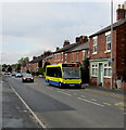
Yellow and blue bus for Crewe in Nantwich
The bus on Route 39 to Crewe is at a London Road bus stop.
Image: © Jaggery
Taken: 13 Oct 2016
0.03 miles
4
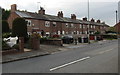
Row of London Road houses, Nantwich
Extending for 50 metres along the south side of the B5074 London Road.
Image: © Jaggery
Taken: 13 Oct 2016
0.03 miles
5
Jensen Photography Nantwich
Weddings photographer at 41 London Road on the right.
Image: © Jaggery
Taken: 13 Oct 2016
0.05 miles
6
Barratt's Coaches office in Nantwich
Local family-run Barratt's Coaches Ltd is based here at 48 London Road, Nantwich.
Image: © Jaggery
Taken: 13 Oct 2016
0.07 miles
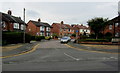
7
Stapeley Terrace, Nantwich
On the south side of the B5074 London Road.
Image: © Jaggery
Taken: 13 Oct 2016
0.08 miles
8
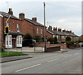
Your Speed indicator, London Road, Nantwich
The yellow-edged sign on the left lights up to display the speed of an approaching vehicle.
The display is in green if within the speed limit, in red if over the limit.
Image: © Jaggery
Taken: 13 Oct 2016
0.08 miles
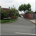
9
Jackson Avenue, Nantwich
Cul-de-sac viewed across London Road.
Image: © Jaggery
Taken: 13 Oct 2016
0.08 miles
10

Row of houses, London Road, Nantwich
The Regents Park Business Centre nameboard http://www.geograph.org.uk/photo/5242429 is on the right.
Image: © Jaggery
Taken: 13 Oct 2016
0.08 miles