IMAGES TAKEN NEAR TO
Mount Close, NANTWICH, CW5 6JJ
Introduction
This page details the photographs taken nearby to Mount Close, CW5 6JJ by members of the Geograph project.
The Geograph project started in 2005 with the aim of publishing, organising and preserving representative images for every square kilometre of Great Britain, Ireland and the Isle of Man.

There are currently over 7.5m images from over14,400 individuals and you can help contribute to the project by visiting https://www.geograph.org.uk
Image Map
Images are licensed for reuse under creativecommons.org/licenses/by-sa/2.0
Notes
- Clicking on the map will re-center to the selected point.
- The higher the marker number, the further away the image location is from the centre of the postcode.
Image Listing (29 Images Found)
Images are licensed for reuse under creativecommons.org/licenses/by-sa/2.0
Image
Details
Distance
1
Imperial Court, Nantwich
Recently-built houses on the east side of Millstone Lane viewed in October 2016.
Image: © Jaggery
Taken: 26 Oct 2016
0.09 miles
2
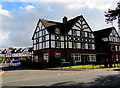
Junction of Millstone Lane and Heathside, Nantwich
Viewed across the B5074 Millstone Lane. This is one of two arms of Heathside. A sign shows HEATHSIDE 4-10.
Image: © Jaggery
Taken: 26 Oct 2016
0.10 miles
3
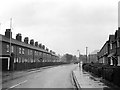
Millstone Lane, Nantwich ? 1963
This was an effective inner bypass to the town centre, but still carried the main A51 traffic. The current by-pass had yet to be built.
Image: © Alan Murray-Rust
Taken: 15 Sep 1963
0.13 miles
4
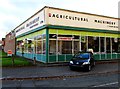
Agricultural Machinery (Nantwich) Ltd
On the corner of Millstone Lane and The Crescent, Nantwich.
Image: © Jaggery
Taken: 26 Oct 2016
0.14 miles
5
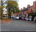
The Crescent, Nantwich
Row of houses extending for about 75 metres, set back from the south side of Beam Street.
Crescent Garage http://www.geograph.org.uk/photo/5171819 on the right is on the corner of St Lawrence Court.
Image: © Jaggery
Taken: 26 Oct 2016
0.16 miles
6
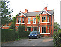
Ash Villas, Crewe Road, E Nantwich
This pair of late Victorian/Edwardian red-brick villas is typical of the many large houses that line Crewe Road on the east side of the town centre. Features include decorative timberwork, stone lintels and brick detailing
Image: © Espresso Addict
Taken: 12 Oct 2006
0.17 miles
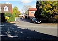
7
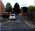
Turner Street, Nantwich
On the east side of Millstone Lane.
Image: © Jaggery
Taken: 26 Oct 2016
0.17 miles
8
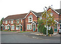
Whitewell Close, Crewe Road, E Nantwich
Modern developments are relatively rare in this gridsquare. This small development to the north of Crewe Road imitates surrounding late Victorian/Edwardian buildings with brick detailing and decorative timberwork
Image: © Espresso Addict
Taken: 12 Oct 2006
0.17 miles
9
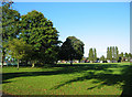
Recreational ground near The Barony
Large recreational ground north east of Nantwich centre, also in Image This part of the park, bounded by Barony Road and Park View, has a pavilion, bowling green, tennis courts, five-a-side pitches, children's playground and skate/bike park
Image: © Espresso Addict
Taken: 9 Oct 2006
0.18 miles
10
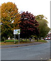
Autumn colours in Nantwich
Trees at the southern edge of Coronation Gardens viewed across Beam Street on October 26th 2016.
Image: © Jaggery
Taken: 26 Oct 2016
0.18 miles