IMAGES TAKEN NEAR TO
Sharratt Square, NANTWICH, CW5 6GE
Introduction
This page details the photographs taken nearby to Sharratt Square, CW5 6GE by members of the Geograph project.
The Geograph project started in 2005 with the aim of publishing, organising and preserving representative images for every square kilometre of Great Britain, Ireland and the Isle of Man.

There are currently over 7.5m images from over14,400 individuals and you can help contribute to the project by visiting https://www.geograph.org.uk
Image Map
Images are licensed for reuse under creativecommons.org/licenses/by-sa/2.0
Notes
- Clicking on the map will re-center to the selected point.
- The higher the marker number, the further away the image location is from the centre of the postcode.
Image Listing (58 Images Found)
Images are licensed for reuse under creativecommons.org/licenses/by-sa/2.0
Image
Details
Distance
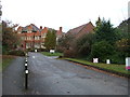
1

Entrance to Regents Park Business Centre, Nantwich
From the north side of London Road. This is also the way to Nantwich Elim Church.
Image: © Jaggery
Taken: 13 Oct 2016
0.05 miles
2
Regents Park Business Centre, Nantwich
Regents Park is home to the Nantwich Elim Church and other organisations and businesses.
Image: © JThomas
Taken: 12 Nov 2016
0.07 miles
3

Entrance to the Elim Church Centre, Nantwich
From the north side of St Joseph's Way, near the London Road junction.
Image: © Jaggery
Taken: 13 Oct 2016
0.08 miles
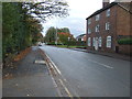
4
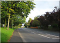
Leafy suburbia, E Nantwich
Crewe Road (A534) in the west of the gridsquare is flanked with mature trees, with a narrow stretch of grass to the north (left). Large (semi-)detached houses predominate, including both Victorian/Edwardian and c.1950s. The turning on the left (yellow car) is Image, one of two roads accessing an extensive housing estate to the north of Crewe Road
Image: © Espresso Addict
Taken: 12 Oct 2006
0.08 miles
5
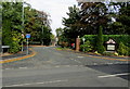
St Joseph's Way, Nantwich
The western end of a long cul-de-sac viewed across the B5074 London Road.
Image: © Jaggery
Taken: 13 Oct 2016
0.09 miles
6

Row of houses, London Road, Nantwich
The Regents Park Business Centre nameboard http://www.geograph.org.uk/photo/5242429 is on the right.
Image: © Jaggery
Taken: 13 Oct 2016
0.10 miles
7
Nantwich Elim Pentecostal Church nameboard, Nantwich
Facing London Road. The access road to the church, and to Regents Park Business Centre, is on the left. http://www.geograph.org.uk/photo/5242422
Image: © Jaggery
Taken: 13 Oct 2016
0.10 miles
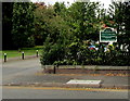
8

Regents Park Business Centre nameboard, Nantwich
Facing London Road, alongside the entrance http://www.geograph.org.uk/photo/5242422 to the business centre.
Image: © Jaggery
Taken: 13 Oct 2016
0.10 miles
10

Marlow House, Nantwich
Viewed across St Joseph's Way.
Image: © Jaggery
Taken: 13 Oct 2016
0.10 miles