IMAGES TAKEN NEAR TO
Highfield Drive, NANTWICH, CW5 6EU
Introduction
This page details the photographs taken nearby to Highfield Drive, CW5 6EU by members of the Geograph project.
The Geograph project started in 2005 with the aim of publishing, organising and preserving representative images for every square kilometre of Great Britain, Ireland and the Isle of Man.

There are currently over 7.5m images from over14,400 individuals and you can help contribute to the project by visiting https://www.geograph.org.uk
Image Map
Images are licensed for reuse under creativecommons.org/licenses/by-sa/2.0
Notes
- Clicking on the map will re-center to the selected point.
- The higher the marker number, the further away the image location is from the centre of the postcode.
Image Listing (8 Images Found)
Images are licensed for reuse under creativecommons.org/licenses/by-sa/2.0
Image
Details
Distance
1
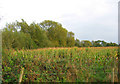
Sweetcorn field by Cheney Brook
Around two-thirds of the gridsquare is farmland, with sweetcorn and cattle pasture being the predominant uses. Cheney Brook runs through the line of willows. View from footpath from Birchin Lane to Colleys Lane
Image: © Espresso Addict
Taken: 12 Oct 2006
0.20 miles
2
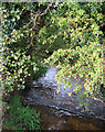
Weir on Cheney Brook
A narrow strip of mixed woodland with beech, hawthorn and willow runs along the brook, dividing pasture on the west from sweetcorn on the east. View by footbridge, on the footpath from Birchin Lane to Colleys Lane
Image: © Espresso Addict
Taken: 12 Oct 2006
0.21 miles
3
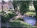
The Weir on Cheney Brook
This curious weir serves no apparent purpose, the weir only drops 10-12" (250mm -300mm) and the wall beyond supporting the footbridge has only about 10 courses of brick. The nearest building on the 1910 O.S. map (25" to mile") is over 1/2 mile away.
Image: © Mike Grose
Taken: 10 Apr 2006
0.21 miles
4
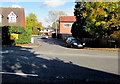
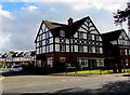
Junction of Millstone Lane and Heathside, Nantwich
Viewed across the B5074 Millstone Lane. This is one of two arms of Heathside. A sign shows HEATHSIDE 4-10.
Image: © Jaggery
Taken: 26 Oct 2016
0.21 miles
5
Imperial Court, Nantwich
Recently-built houses on the east side of Millstone Lane viewed in October 2016.
Image: © Jaggery
Taken: 26 Oct 2016
0.24 miles
6
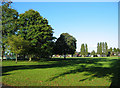
Recreational ground near The Barony
Large recreational ground north east of Nantwich centre, also in Image This part of the park, bounded by Barony Road and Park View, has a pavilion, bowling green, tennis courts, five-a-side pitches, children's playground and skate/bike park
Image: © Espresso Addict
Taken: 9 Oct 2006
0.24 miles
7
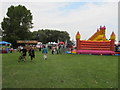
North West Triathlon, bouncy castle (for spectators)
This triathlon is a great spectator event, particularly for the families of competitors. At the swimming pool you can get into the side of the pool, in the park there are amusements like this bouncy castle, food stalls, and a shop for triathlon equipment. There is plenty of car parking at one end of the park.
Image: © David Hawgood
Taken: 5 Sep 2010
0.25 miles
8
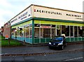
Agricultural Machinery (Nantwich) Ltd
On the corner of Millstone Lane and The Crescent, Nantwich.
Image: © Jaggery
Taken: 26 Oct 2016
0.25 miles