IMAGES TAKEN NEAR TO
Aston Juxta Mondrum, NANTWICH, CW5 6DS
Introduction
This page details the photographs taken nearby to CW5 6DS by members of the Geograph project.
The Geograph project started in 2005 with the aim of publishing, organising and preserving representative images for every square kilometre of Great Britain, Ireland and the Isle of Man.

There are currently over 7.5m images from over14,400 individuals and you can help contribute to the project by visiting https://www.geograph.org.uk
Image Map
Images are licensed for reuse under creativecommons.org/licenses/by-sa/2.0
Notes
- Clicking on the map will re-center to the selected point.
- The higher the marker number, the further away the image location is from the centre of the postcode.
Image Listing (6 Images Found)
Images are licensed for reuse under creativecommons.org/licenses/by-sa/2.0
Image
Details
Distance
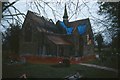
2
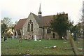
St. Oswald's Church, Worleston
Taken when the monumental inscriptions were being transcribed in 1996, a disastrous fire caused by an electrical fault burned the organ loft and most of the chancel roof - since been restored.
Image: © Mike Grose
Taken: Unknown
0.22 miles
3
St. Oswald's Church, Worleston after the fire
Following a fire in the early hours of the morning of 22 December 1997 the church has been fenced off pending investigation and restoration
Image: © Mike Grose
Taken: Unknown
0.22 miles
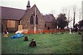
4
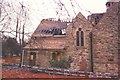
St. Oswald's Church, Worleston after the fire
Showing the extent of the damage to the chancel and organ loft
Image: © Mike Grose
Taken: Unknown
0.22 miles
5
St. Oswald's Church, Worleston after the fire
Shows that the organ loft roof has burnt out completely. Extensive repairs to the interior, especially the roof timbers took quite some time. The small spire is in the centre of the crossing and needed substantial support during repairs.
Image: © Mike Grose
Taken: Unknown
0.22 miles