IMAGES TAKEN NEAR TO
Worleston Road, NANTWICH, CW5 6DH
Introduction
This page details the photographs taken nearby to Worleston Road, CW5 6DH by members of the Geograph project.
The Geograph project started in 2005 with the aim of publishing, organising and preserving representative images for every square kilometre of Great Britain, Ireland and the Isle of Man.

There are currently over 7.5m images from over14,400 individuals and you can help contribute to the project by visiting https://www.geograph.org.uk
Image Map
Images are licensed for reuse under creativecommons.org/licenses/by-sa/2.0
Notes
- Clicking on the map will re-center to the selected point.
- The higher the marker number, the further away the image location is from the centre of the postcode.
Image Listing (3 Images Found)
Images are licensed for reuse under creativecommons.org/licenses/by-sa/2.0
Image
Details
Distance
1
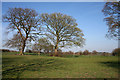
Pasture by Mile House Farm
Flattish pasture with mature deciduous trees in the field boundaries to the north east of Mile House Farm
Image: © Espresso Addict
Taken: 5 Apr 2007
0.05 miles
2
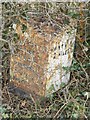
Old Milepost by the B5074, south of Worleston
Cast iron post by the B5074, in parish of Worleston (Crewe and Nantwich District), South of Park Farm, on the verge, on West side of road. Cast iron CCC1896, erected by the County Council in the 19th century.
Inscription reads:-
: (---) / MILES / CHURCH / MINSHULL 4 / WINSFORD 5 : : CHESHIRE / 1896 / COUNTY COUNCIL : : NANTWICH / 2 MILES :
Maker:-
: W H SMITH & CO / MAKERS / WHITCHURCH :
Milestone Society National ID: CH_NWWF02
Image: © J Higgins
Taken: 1 Mar 2004
0.16 miles
3
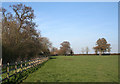
Pasture south of Park Farm
Flat lush pasture west of the B5074. The trees in the boundary (left) form part of the small wood marked on the 1:25,000 map. View from the public footpath from Park Farm to Rease Heath
Image: © Espresso Addict
Taken: 5 Apr 2007
0.18 miles