IMAGES TAKEN NEAR TO
/The Drive, NANTWICH, CW5 6DG
Introduction
This page details the photographs taken nearby to /The Drive, CW5 6DG by members of the Geograph project.
The Geograph project started in 2005 with the aim of publishing, organising and preserving representative images for every square kilometre of Great Britain, Ireland and the Isle of Man.

There are currently over 7.5m images from over14,400 individuals and you can help contribute to the project by visiting https://www.geograph.org.uk
Image Map
Images are licensed for reuse under creativecommons.org/licenses/by-sa/2.0
Notes
- Clicking on the map will re-center to the selected point.
- The higher the marker number, the further away the image location is from the centre of the postcode.
Image Listing (6 Images Found)
Images are licensed for reuse under creativecommons.org/licenses/by-sa/2.0
Image
Details
Distance
1
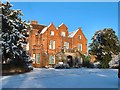
Reaseheath Hall
Reaseheath in the snow!
Image: © Bill Pearson
Taken: 26 Dec 2004
0.03 miles
3
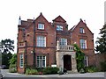
Reaseheath College
This part of the college used to be part of a country estate up until about the First World War http://www.reaseheath.ac.uk/thecollege/history/index.html
Image: © Tom McCallister
Taken: 22 Sep 2008
0.11 miles

6
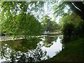
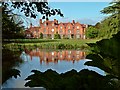
College Lake
Reaseheath College near Nantwich
Image: © Andy and Hilary
Taken: 15 May 2005
0.21 miles