IMAGES TAKEN NEAR TO
Nantwich Road, NANTWICH, CW5 6BE
Introduction
This page details the photographs taken nearby to Nantwich Road, CW5 6BE by members of the Geograph project.
The Geograph project started in 2005 with the aim of publishing, organising and preserving representative images for every square kilometre of Great Britain, Ireland and the Isle of Man.

There are currently over 7.5m images from over14,400 individuals and you can help contribute to the project by visiting https://www.geograph.org.uk
Image Map
Images are licensed for reuse under creativecommons.org/licenses/by-sa/2.0
Notes
- Clicking on the map will re-center to the selected point.
- The higher the marker number, the further away the image location is from the centre of the postcode.
Image Listing (26 Images Found)
Images are licensed for reuse under creativecommons.org/licenses/by-sa/2.0
Image
Details
Distance
2
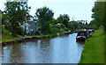
The Shropshire Union Canal at Wardle
Looking northwest from Bridge 101.
Image: © M J Richardson
Taken: 21 Sep 2013
0.09 miles
4
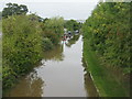
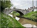
Shropshire Union Canal - Goodwin Bridge
Looking south east to Goodwin Bridge
Image: © Pierre Terre
Taken: 20 May 2005
0.13 miles
6

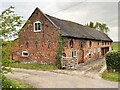
Brick barn at Wardle Old Hall
On the north side of Bridge 101 over the Shropshire Union Canal at Wardle.
Image: © M J Richardson
Taken: 21 Sep 2013
0.13 miles
7
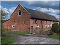
Attractive brick building at Wardle Old Hall
Image: © David Martin
Taken: 12 Apr 2012
0.13 miles
8
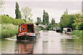
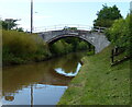
Goodwin's Bridge
Bridge 101 on the Shropshire Union Canal
Image: © Andrew Abbott
Taken: 1 May 2022
0.14 miles
10
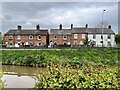
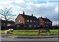
Cottages on Nantwich Road
At Barbridge.
Image: © Andrew Abbott
Taken: 1 May 2022
0.15 miles