IMAGES TAKEN NEAR TO
Falcon Way, NANTWICH, CW5 5XS
Introduction
This page details the photographs taken nearby to Falcon Way, CW5 5XS by members of the Geograph project.
The Geograph project started in 2005 with the aim of publishing, organising and preserving representative images for every square kilometre of Great Britain, Ireland and the Isle of Man.

There are currently over 7.5m images from over14,400 individuals and you can help contribute to the project by visiting https://www.geograph.org.uk
Image Map
Images are licensed for reuse under creativecommons.org/licenses/by-sa/2.0
Notes
- Clicking on the map will re-center to the selected point.
- The higher the marker number, the further away the image location is from the centre of the postcode.
Image Listing (60 Images Found)
Images are licensed for reuse under creativecommons.org/licenses/by-sa/2.0
Image
Details
Distance
1
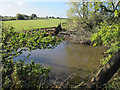
Ponds near Fields Farm
On the outskirts of Nantwich. View towards new housing.
Image: © JThomas
Taken: 14 Mar 2019
0.12 miles
2
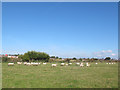
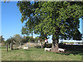
Sheep on a mission
There was no obvious source of food, but all these sheep were walking or even running in the same direction. What attracted them?
Image: © Stephen Craven
Taken: 27 Sep 2015
0.15 miles
3
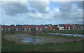
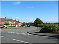
Semi-detached houses on Queens Drive
A large housing estate lies to the SW of Nantwich, bordered on the south and east by Queens Drive. The semi-detached houses here are typical of the older style of house in the estate. The grassed area on the right is Queens Drive Meadows. View north from the road bend
Image: © Espresso Addict
Taken: 9 Oct 2006
0.15 miles
4
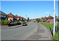
Housing estate, SW Nantwich
An extensive estate of semi-detached houses is situated to the SW of Nantwich. The majority of the houses probably date from the 1950s, with more recent additions. This view shows the junction of Queens Drive and Marsh Lane at the south-west corner, by the Shropshire Union Canal. Fields Farm is visible on the right of frame
Image: © Espresso Addict
Taken: 9 Oct 2006
0.16 miles
5
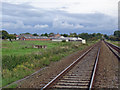
Edleston: footpath crossing on the Nantwich/Whitchurch railway
Edleston: footpath crossing the Nantwich/Whitchurch railway near Fields Farm (in the distance). View towards Nantwich.
Image: © Mike Harris
Taken: 4 Oct 2006
0.17 miles
6
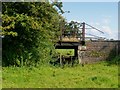
Railway underpass
This underpass is below the former track of the Nantwich to Market Drayton railway.
Image: © Ceri Thomas
Taken: 9 Aug 2009
0.17 miles
7
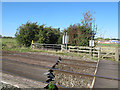
Green Lane level crossing
The "lane" is at this point only a bridleway along the edge of a field; the crossing is a user-worked one for farm traffic and pedestrians. See also Image
The sheep are the tail end of the flock seen in Image
Image: © Stephen Craven
Taken: 27 Sep 2015
0.17 miles
8
Green Lane level crossing (detail)
The "lane" is at this point only a bridleway; the crossing is a user-worked one for farm traffic and pedestrians, with separate gates for each. See also Image
Image: © Stephen Craven
Taken: 27 Sep 2015
0.17 miles
9
Green Lane towards the railway line
The fence to the left is on the perimeter of a new housing estate Image
Image: © Stephen Craven
Taken: 27 Sep 2015
0.18 miles