IMAGES TAKEN NEAR TO
The Blankney, NANTWICH, CW5 5TW
Introduction
This page details the photographs taken nearby to The Blankney, CW5 5TW by members of the Geograph project.
The Geograph project started in 2005 with the aim of publishing, organising and preserving representative images for every square kilometre of Great Britain, Ireland and the Isle of Man.

There are currently over 7.5m images from over14,400 individuals and you can help contribute to the project by visiting https://www.geograph.org.uk
Image Map
Images are licensed for reuse under creativecommons.org/licenses/by-sa/2.0
Notes
- Clicking on the map will re-center to the selected point.
- The higher the marker number, the further away the image location is from the centre of the postcode.
Image Listing (387 Images Found)
Images are licensed for reuse under creativecommons.org/licenses/by-sa/2.0
Image
Details
Distance
1
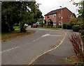
The Blankney, Nantwich
Houses at the northern end of The Blankney, a cul-de-sac extending
for 125 metres from the south side of the B5341 Waterlode.
Image: © Jaggery
Taken: 13 Oct 2016
0.02 miles
2
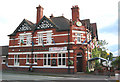
Railway Hotel, Pillory Street, Nantwich
Victorian red-brick public house cum B&B, around 50 m from the station (in Image). The arched doorway is unusual in Nantwich
Image: © Espresso Addict
Taken: 3 Oct 2006
0.04 miles
3
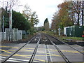
Railway heading south west from Nantwich Railway Station
View from the level crossing on Pillory Street (B5341).
Image: © JThomas
Taken: 12 Nov 2016
0.05 miles
4
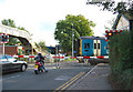
Train at level crossing by Nantwich station
The frequent trains at this level crossing on Wellington Road (part of the A530) often make for traffic congestion. The station is just out of frame on the left
Image: © Espresso Addict
Taken: 3 Oct 2006
0.05 miles
5
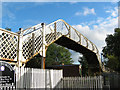
Wrought iron bridge, Nantwich station
Pedestrian bridge by the level crossing on Wellington Road. Nantwich station is left of frame, beyond the bridge. A detail is shown in Image
Image: © Espresso Addict
Taken: 3 Oct 2006
0.05 miles
6
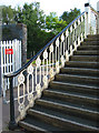
Wrought ironwork, Nantwich station
Detail of wrought ironwork of the pedestrian bridge at Nantwich station depicted in Image
Image: © Espresso Addict
Taken: 3 Oct 2006
0.05 miles
7
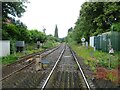
Railway towards Shrewsbury
Looking west from the level crossing on Wellington Road.
Image: © JThomas
Taken: 3 Jul 2024
0.05 miles
8
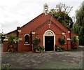
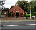
St Anne's Catholic Church, Nantwich
The church is set back from the west side of Pillory Street, opposite Nantwich railway station.
A nearby nameboard shows DIOCESE OF SHREWSBURY
CATHOLIC PARISH CHURCH OF ST ANNE'S NANTWICH.
Image: © Jaggery
Taken: 13 Oct 2016
0.06 miles
9
St Anne's Catholic Church, Nantwich
Viewed across Pillory Street, opposite Nantwich railway station.
The black nameboard on the left shows DIOCESE OF SHREWSBURY
CATHOLIC PARISH CHURCH OF ST ANNE'S NANTWICH.
http://www.geograph.org.uk/photo/5153265 to a closer view of the church.
Image: © Jaggery
Taken: 13 Oct 2016
0.06 miles
10
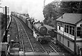
Northbound parcels train at Nantwich ? 1963
Headed by former Great Western Railway Grange class 4-6-0 no.6863 'Dolhywel Grange'
Image: © Alan Murray-Rust
Taken: 15 Sep 1963
0.06 miles