IMAGES TAKEN NEAR TO
Rookery Close, NANTWICH, CW5 5SJ
Introduction
This page details the photographs taken nearby to Rookery Close, CW5 5SJ by members of the Geograph project.
The Geograph project started in 2005 with the aim of publishing, organising and preserving representative images for every square kilometre of Great Britain, Ireland and the Isle of Man.

There are currently over 7.5m images from over14,400 individuals and you can help contribute to the project by visiting https://www.geograph.org.uk
Image Map
Images are licensed for reuse under creativecommons.org/licenses/by-sa/2.0
Notes
- Clicking on the map will re-center to the selected point.
- The higher the marker number, the further away the image location is from the centre of the postcode.
Image Listing (292 Images Found)
Images are licensed for reuse under creativecommons.org/licenses/by-sa/2.0
Image
Details
Distance
1
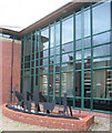
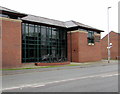
Nantwich Veterinary Hospital, Crewe Road
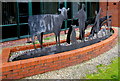
The windows of this red brick and glass building, opened in 1998, reflect the Victorian terrace houses opposite. The metal sculpture portrays the building's use as a veterinary hospital. Located on the mini-roundabout at the end of Crewe Road, this building forms a dramatic contrast to the Elizabethan timbered Churche's Mansion opposite. See also Image
Image: © Espresso Addict
Taken: 12 Oct 2006
0.02 miles
2
Sculpture at Nantwich Veterinary Hospital
Detail of the metal sculpture at Image
Image: © Espresso Addict
Taken: 12 Oct 2006
0.02 miles
3
West along South Crofts, Nantwich
South Crofts is a cul-de-sac on the west side of Millstone Lane. The car is on the corner of North Crofts.
Image: © Jaggery
Taken: 13 Oct 2016
0.03 miles
4
Nantwich Exchange
Nantwich Exchange (identifier WMNAN) is BT premises set back from the north side of Hospital Street.
Image: © Jaggery
Taken: 13 Oct 2016
0.03 miles
5
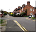
140-142 Hospital Street, Nantwich
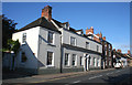
View west along Hospital Street, early on a summer's morning, near the Churche's Mansion roundabouts. The grade-II-listed white-rendered building (left) is 140-142 Hospital Street, dating originally from the 17th century and on the site of the Hospice of St Nicholas of 1083 which gives the street its name. A plaque claims it is the birthplace of Randulph Crewe, who became Lord Chief Justice in 1625. The building to its right (136-138 Hospital Street) is also listed, as are several others also visible (right). For more details, see: http://en.wikipedia.org/wiki/Listed_buildings_in_Nantwich%2C_Cheshire
Image: © Espresso Addict
Taken: 11 Aug 2007
0.03 miles
6
Metal silhouettes outside Nantwich Veterinary Hospital, Nantwich
On the Crewe Road side of this http://www.geograph.org.uk/photo/5159341 building.
Image: © Jaggery
Taken: 13 Oct 2016
0.04 miles
7
Silhouette detail south side, Crewe Road, Nantwich
Located here. http://www.geograph.org.uk/photo/5159351 See http://www.geograph.org.uk/photo/5159353 for the view from the opposite side.
Image: © Jaggery
Taken: 13 Oct 2016
0.04 miles
8
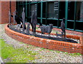
Silhouette detail north side, Crewe Road, Nantwich
Located here. http://www.geograph.org.uk/photo/5159351 See http://www.geograph.org.uk/photo/5159352 for the view from the opposite side.
Image: © Jaggery
Taken: 13 Oct 2016
0.04 miles
9
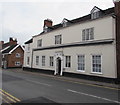
Grade II listed number 140 Hospital Street, Nantwich
The 17th century building was Grade II listed in 1948.
Image: © Jaggery
Taken: 13 Oct 2016
0.04 miles
10
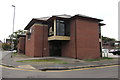
Nantwich Veterinary Hospital, Nantwich
Opposite Crewe Road, viewed from the corner of Millstone Lane and South Crofts.
Image: © Jaggery
Taken: 13 Oct 2016
0.04 miles