IMAGES TAKEN NEAR TO
Pratchitts Row, NANTWICH, CW5 5SB
Introduction
This page details the photographs taken nearby to Pratchitts Row, CW5 5SB by members of the Geograph project.
The Geograph project started in 2005 with the aim of publishing, organising and preserving representative images for every square kilometre of Great Britain, Ireland and the Isle of Man.

There are currently over 7.5m images from over14,400 individuals and you can help contribute to the project by visiting https://www.geograph.org.uk
Image Map
Images are licensed for reuse under creativecommons.org/licenses/by-sa/2.0
Notes
- Clicking on the map will re-center to the selected point.
- The higher the marker number, the further away the image location is from the centre of the postcode.
Image Listing (407 Images Found)
Images are licensed for reuse under creativecommons.org/licenses/by-sa/2.0
Image
Details
Distance
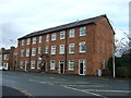
2
Hospital Street mini-roundabout, Nantwich
At the Pratchitts Row junction.
Image: © Jaggery
Taken: 13 Oct 2016
0.04 miles
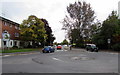
3
Former Cheshire Hounds pub, Hospital Street, Nantwich
Now in residential use.
Image: © Jaggery
Taken: 13 Oct 2016
0.05 miles

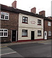
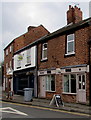
5

Barrel & Tap in Nantwich
Recently-opened craft pub and bottle shop at 90 Hospital Street, viewed in October 2016.
An October 2015 Google Earth Street View shows Amici Italian restaurant here.
Image: © Jaggery
Taken: 13 Oct 2016
0.06 miles
6
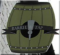
Barrel & Tap name sign, Nantwich
Hanging from the wall bracket here. http://www.geograph.org.uk/photo/5157617
Image: © Jaggery
Taken: 13 Oct 2016
0.06 miles
7
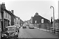
Hospital Street, Nantwich ? 1963
At this time it still carried through traffic from the east making its way to the A530.
Image: © Alan Murray-Rust
Taken: 15 Sep 1963
0.06 miles
8
1828 in Hospital Street, Nantwich
1828 at 88 Hospital Street is a women's clothes shop specialising in sizes 18 to 28.
The Barrel & Tap http://www.geograph.org.uk/photo/5157617 is on the left.
Image: © Jaggery
Taken: 13 Oct 2016
0.06 miles
9
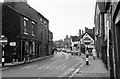
Hospital Street, Nantwich ? 1963
Still forming part of the A51 through the town, as part of a one-way system, although through traffic was routed via Millstone Lane and Beam Bridge.
Image: © Alan Murray-Rust
Taken: 15 Sep 1963
0.06 miles
10
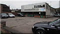
C. Latham Motors, Nantwich
Garage set back from Hospital Street.
Image: © Jaggery
Taken: 13 Oct 2016
0.06 miles